There is another issue between RDF and GPS. With GPS one has a pretty good idea of the distance to the last packet before going off to recover.
RDF one has to shoot a line and hopefully go in the general direction of the rocket. If it goes out of range, one has to hope they get close enough
to get another fix. The sight n' go feature with some of the Garmin handheld GPS units can help in that regard with RDF tracking. Point the Garmin in the direction of the yagi antenna and will lock a datum line to follow. With RDF make sure one has a receiver with a true signal strength meter. A UV-5RS
meter is full on or off. No relative signal strength on the indicator with that radio.
A GPS tracking system can take one right to the last packet which in some cases is where the rocket lies or close enough to pickup a new packet.
Also, with a completely disappearing rocket, one that is launched and no trace is seen of it no events or what have you, it either means total recovery
failure or the rocket is so far out, it can't be seen. RDF will get one a line hopefully, whereas one can determine from the GPS display in some systems that the deployment events have occurred in sequence or lack thereof and the GPS altitude of the decending rocket.
Another factor is time. If one lives in a area where weather is variable, seasonable and the frequency of launches sparse, would be nice to get the rocket back in a quick fashion so one can fly the next one. If one lives with year round flyable weather and an accessible launch site, the pressure to fly might not be as great. If it takes a long time to find a particular rocket, it's not a big deal to them. I'm in the former position and lost a lot of flight opportunities searching for
"lost" rockets before incorporating tracking.
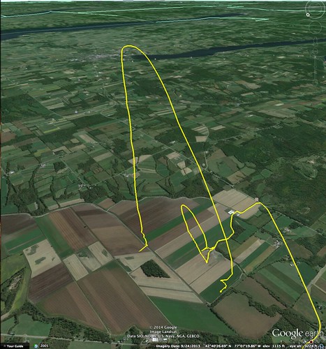
For those that fly in a "featureless" expanse of land, two dots and a line is all that's needed with a GPS tracker. For those in the central part of the country with farmland, it might be helpful to "see" a tentative recovery site with respect to nearby roads and landmarks. Would help with driving close to the landing site.
There are some folks who are masters with RDF and looks to me they are so good, they can smell the direction to point the antenna.
")
Of course if a visual is had of the descending rocket, RDF certainly can effect recovery out of standing vegetation or corn stubble. One plus of RDF is the transmitters are small and tough. I've witnessed several flights where the rocket landed in sight, was recovered and it was discovered the tracker flew off the shockcord after the rocket was brought back. Sure enough, a signal was heard and led the user right up to the tracker lying in the field.
One comment on GPS screens, phones laptops etc. I've seen 5 handheld Garmin units from a monochrome Legend, VistaHcX to a 60CsX and one can generally
hold them at an angle to see the screen in sunlight. They're designed for that. Laptop screens, unless they are a pricey unit designed for sunlight, forget it.
Either put them in a box on a table for a sunshade or use them inside a vehicle and transfer the coordinates to a handheld GPS or phone.
Phones? If you have one you can read in the sun then great, you're lucky. If not, one can try getting a matte screen protector as that can help a little bit or get a little semi-deep cardboard box fitted to your device and spraypaint the inside with flat black paint. If one faces the sun with the device in the box, they will be better able to see the screen. I've done that with a Nexus 7 with an EggFinder receiver and can use a ham radio H/T with a B/T Mobilinkd TNC for APRS tracking when needed. Kurt