I like mine. It isn't super accurate, but I always find my rocket. Except the one time I didn't, and had to buy a new transmitter. But you don't need to get a ham license, you don't need a cell phone, and you don't have to solder it together. There is an online community (Yahoo Groups, I think). And you can download data to Google Earth and see a pretty picture of where your rocket went. A pretty good deal.
Keep in mind that the receiver is not a navigator, and simply reports coordinates. You'll still need a hiking or pedestrian GPS navigator to walk you to the rocket. I use one of these. Pretty
stinkin' cheap.
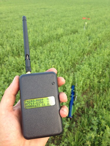
The Etrex Legend will get the job done. No matter what device one uses, sit down, read the manual and especially be fastidious as to how to input the given lat/longitude. You'll have to pay attention whether or not it's Degrees.Decimal Degrees,
Degrees.Minutes.Decimal Minutes, Degrees.Minutes. Seconds. Some mapping GPS mapping units one can chose which units they want to use. Try to set it to the units that your tracker receiver reports so the lat/long can be input directly. If one gets the units incorrectly input, might as well count the rocket as lost. It's best to practice, practice, practice and practice at home and again the night before the planned launch.
I witnessed this happening to a fellow in the past, took him awhile to figure it out to find his rocket. In the meantime he lost a lot of time he could have been flying rockets. There was a very happy ending to this story though. I am addicted to
direct to map tracking and noticed the flier/Ham was using an APRS Kenwood D72A handi-talkie, Beeline 400Mhz (Ham band) GPS tracker and a Garmin 60CsX handheld mapping GPS device. I showed him the Garmin has a serial port and whipped out my 60Cs and demonstrated the cable to connect the Kenwood to the Garmin and not have to mess with inputting data. Just push a button and tell the Garmin to navigate to the last known rocket position.
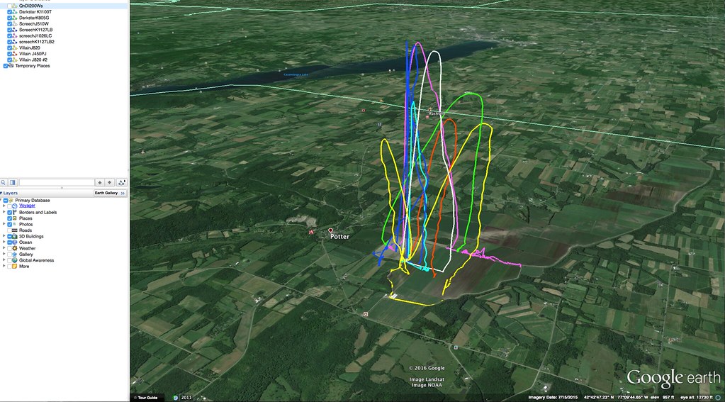
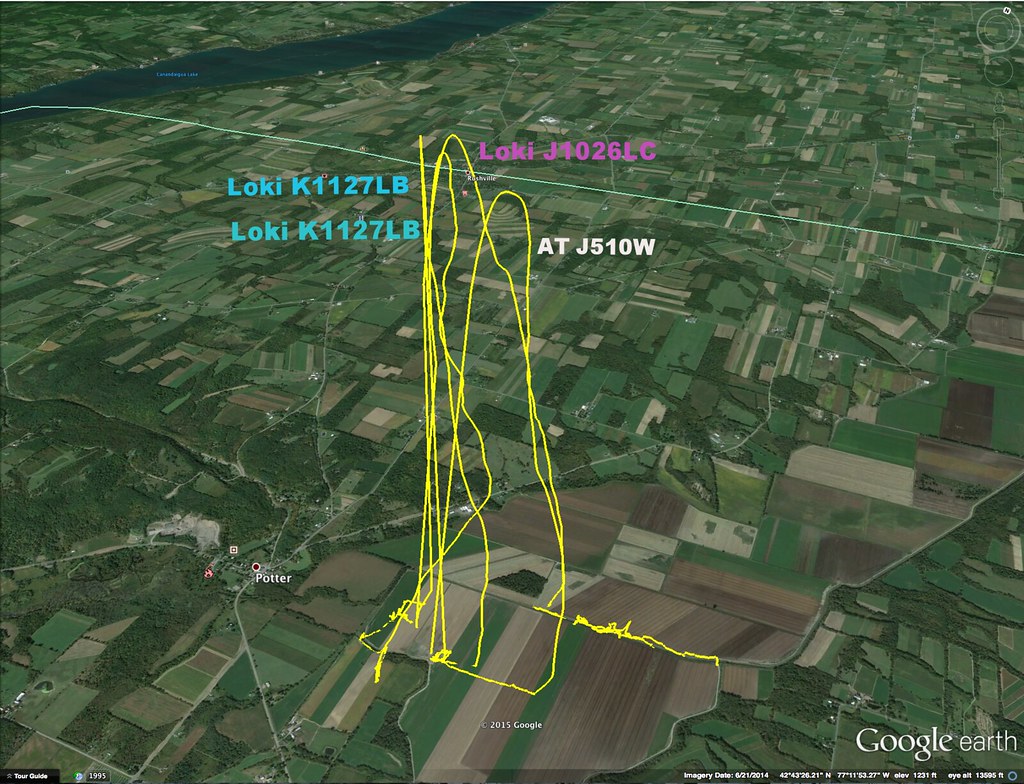
Live tracking on a map is a bit more helpful because one has an idea of drift versus simply proceeding to the last known position. If it's a nominal flight, one will likely get within the ground footprint of the tracker and get a final location of where the rocket is lying.
One advantage I had was finding a ballistic flight with like 2 to 3 position packets only:
https://www.rocketryforum.com/showt...-Mapping-Program-Update&p=1573624#post1573624
The software is a ham tracking program called APRSISCE/32
https://aprsisce.wikidot.com/ The potential is there to run two instances of the program and get the live rocket position data on a photomap that's cacheable in real time during the flight.
Only problem with this stuff is usually one has to have a Ham callsign to get the program to open though there is no checking. One technically could use a fictitious callsign and as long as they're using it with their no "license required equipment"
wouldn't be a problem.
The 900Mhz Beeline is perfect for one who doesn't want to build a device and have a turnkey GPS tracking solution. I did check with Greg and the position data is handled differently than a typical NMEA stream (National, Marine, Electronics, Association) that comes out of a GPS receiver. Wouldn't be able to use the Beeline as a direct NMEA source with the above software or the Android program GPS Rocket Locator. GPS Rocket Locator unfortunately
needs a live internet connection for the map to be displayed.
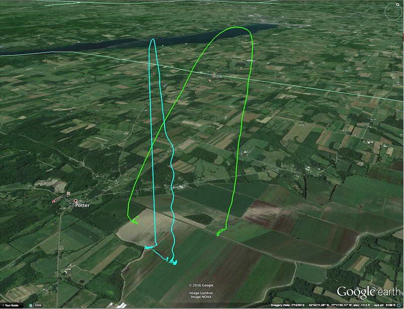
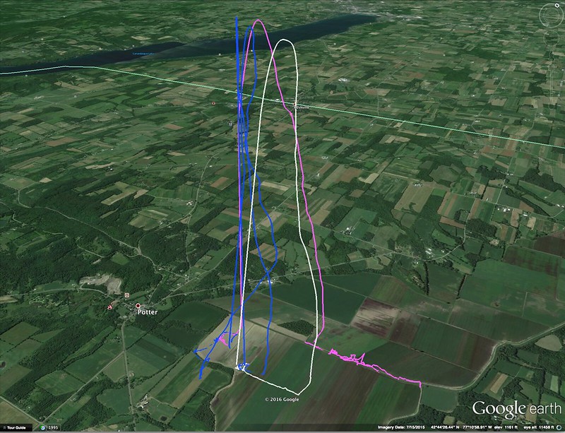
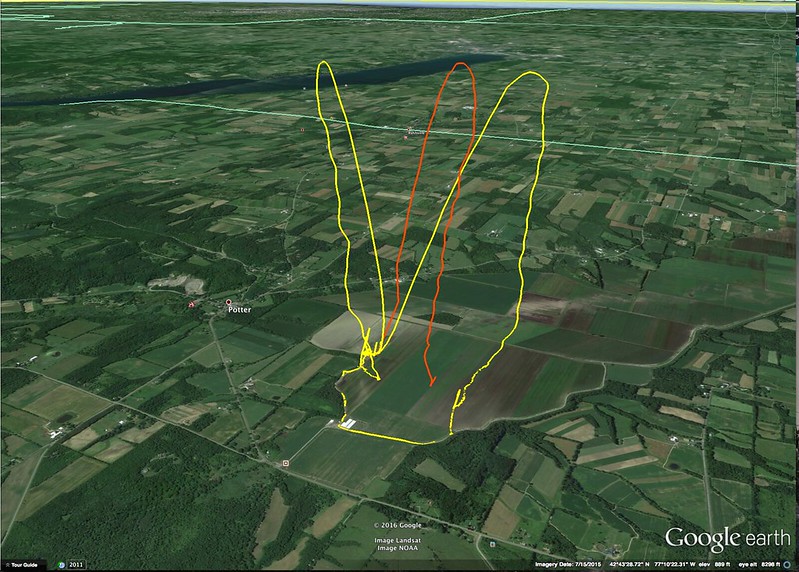
I've had nine completely sight unseen flights that would have been lost if not for an APRS or NMEA GPS tracker. The longer one's rocket stays out of sight, the greater the chance they'll miss the deployment events and might not get a visual fix
at all. I never saw a Wildman Jr. after various J flights from 4500 to 6700 feet with one of the missing flights landing 3/4ths of a mile away. Didn't see it under the 36 inch main but yet I walked right up to the rocket and the main was out and not a scratch on the paint. If you fly a small rocket high, you'll lose it if there is no tracker onboard sooner rather than later.
One more advantage to GPS over RDF tracking is if a ballistic flight occurs, all it takes is a few position packets and one has a better chance of finding the remains. Really not enough time to acquire/fix an RDF bearing and lock it in to get to the crash site. In my case that's all it took to find the Formula 54 which actually was intact in the ground. If I had the right digging tool, I could have saved the nosecone. I have a new Wildman nosecone I like even better than the one RW provided and have just one more thrust block to epoxy to the sled and I'll be ready to fly again.
One last tip: Don't use a 900Mhz Yagi to track a rocket that's in flight. The beamwidth of the Yagi on that frequency is pretty narrow and one could have trouble keeping a lock on the datastream. Hard to point an antenna with a very narrow beamwidth at something you can't see. Use the "stick" antenna that comes with the receiver or if
one is really anal retentive, get a patch antenna (shown below) to increase the receive gain. Now a Yagi can still be helpful and a 900Mhz one is not that hard to carry. The time to use the Yagi is when the rocket is down and one is proceeding to the recovery site.
At that time, the rocket usually is not moving (unless it's being blown by the wind across the ground) and here's where the Yagi can be helpful to improve the "ground" footprint of your 900Mhz tracker. Attach it as you go to the last known position. I've proved this to myself.
I used a Yagi with a downed rocket and as soon as I reacquired a signal, I replaced the stock antenna to the receiver and the signal disappeared. Put the Yagi back and I got decipherable packets. If one is stuck using a 900Mhz tracker with a very extreme flight, a patch
antenna for base monitoring to maximize the prospect of receiving a last position when the rocket is about to touch down. That's what you want, that last position just before touchdown so you'll be within the ground footprint of the tracker so you can get a final position of the resting place. If your last received position is with the rocket up high in the air and drifting (with it being very far downrange) the last position might be quite a distance away from the final resting place. If that is out of range of the ground footprint of the tracker what to do? Well, whip out your Yagi. Forgot that? Here's where real time tracking on a map can help you, you simply continue walking in the direction you see the rocket was drifting and as long as the tracker is functioning, you'll likely walk into the ground footprint.
That is hard to do if one only has the ability to manually input a lat/long into a handheld mapping GPS. The good news is for sport fliers the flights are going to be straight forward and inputting the lat/long into a navigation device is likely going to work 98% of the time
for recovery. If you get to the last known position and see no rocket but a new position is coming in, just input the new coordinates and you're done. Go to it, pick it up and you'll never want to be without a GPS tracker again for the outta sight flights.Kurt


")