


ecarson
Well-Known Member
- Joined
- Mar 21, 2017
- Messages
- 111
- Reaction score
- 18
I've been experimenting the last few days with my U-blox M8N GPS receiver modules. One a stand alone chip I intend for rocket tracking, and the other embedded within a quadcopter navigation module.
The United States has the GPS system satellites, and Russia has the GLONASS system. The European Union has been launching satellites for a newer system called Galileo. Last month, a few more satellites became operational, and several more are in orbit but still being commissioned. I read where the Galileo system should be a fully operational stand alone system by sometime next year. In the mean time, one can track the extra data from the operational satellites for possible extra precision.
Using U-center, a free software from U-Blox, I enabled both chips to receive the Galileo. The M8N chip can receive up to three systems simultaneously. A yet to be released U-Blox F9 series chip, purports to be able to receive 4 systems at once. That could be the Chinese Beidou system in addition to the three already mentioned.
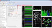
Here are some screen shots of what I did. These are from U-center. I went into configuration view, and selected GNSS. This pops up the various satellite systems available. On both my M8N chips from the factory, only the GPS and GLONASS systems, along with the WAAS augmentation were enabled. Selecting the Galileo checkbox, and hitting "send" completes this part.
Since the Galileo system sends out NMEA 4.1 data, that must also be changed. Both my factory chips were set at NMEA 4.0 from the factory. Once again, select and send. The second screenshot depicts this. This does not affect GPS or GLONASS data.
From a cold start it usually takes up to 2 hours for the chip to gather all the required data (indoors). If the chip module has an onboard battery backed memory, the satellite data can be stored for faster acquisition. My chip has a weak battery, and usually loses the information after 30 minutes of no power.
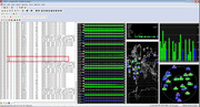
After awhile, the satellites will start appearing. The little flags along the bar graph indicate which satellites are being tracked. The bar graph will switch from blue to green when usable navigation data is being received and incorporated into the position. The third screenshot shows 8 Galileo satellites being tracked, and 2 to 3 already giving usable data. This was after 1 hour from cold start. The little blue flags with the stars (European Union) indicate those particular satellites. NMEA string "GAGSV" verifies that the packet is from a Galileo satellite.
For rocket tracking purposes, I can get the satellite data, along with GPS and GLONASS on GNSS Commander for Android, but as yet have not tried this with Rocket Locator.

The United States has the GPS system satellites, and Russia has the GLONASS system. The European Union has been launching satellites for a newer system called Galileo. Last month, a few more satellites became operational, and several more are in orbit but still being commissioned. I read where the Galileo system should be a fully operational stand alone system by sometime next year. In the mean time, one can track the extra data from the operational satellites for possible extra precision.
Using U-center, a free software from U-Blox, I enabled both chips to receive the Galileo. The M8N chip can receive up to three systems simultaneously. A yet to be released U-Blox F9 series chip, purports to be able to receive 4 systems at once. That could be the Chinese Beidou system in addition to the three already mentioned.
Here are some screen shots of what I did. These are from U-center. I went into configuration view, and selected GNSS. This pops up the various satellite systems available. On both my M8N chips from the factory, only the GPS and GLONASS systems, along with the WAAS augmentation were enabled. Selecting the Galileo checkbox, and hitting "send" completes this part.
Since the Galileo system sends out NMEA 4.1 data, that must also be changed. Both my factory chips were set at NMEA 4.0 from the factory. Once again, select and send. The second screenshot depicts this. This does not affect GPS or GLONASS data.
From a cold start it usually takes up to 2 hours for the chip to gather all the required data (indoors). If the chip module has an onboard battery backed memory, the satellite data can be stored for faster acquisition. My chip has a weak battery, and usually loses the information after 30 minutes of no power.
After awhile, the satellites will start appearing. The little flags along the bar graph indicate which satellites are being tracked. The bar graph will switch from blue to green when usable navigation data is being received and incorporated into the position. The third screenshot shows 8 Galileo satellites being tracked, and 2 to 3 already giving usable data. This was after 1 hour from cold start. The little blue flags with the stars (European Union) indicate those particular satellites. NMEA string "GAGSV" verifies that the packet is from a Galileo satellite.
For rocket tracking purposes, I can get the satellite data, along with GPS and GLONASS on GNSS Commander for Android, but as yet have not tried this with Rocket Locator.
 . IIRC the requirement is above both a certain speed above a certain height. Some manufacturers go "no position" if either is exceeded and/or have more conservative limits than the laws allow, just to make life difficult for us. Trying to get actual information is proving difficult.