Awesome test of Marshall GPS transmitter

The Rocketry Forum

Help Support The Rocketry Forum:

This site may earn a commission from merchant affiliate links, including eBay, Amazon, and others.

kenstarr

Well-Known Member
TRF Supporter
Joined
Jan 19, 2011
Messages
1,486
Reaction score
667
Location
Cache County Utah
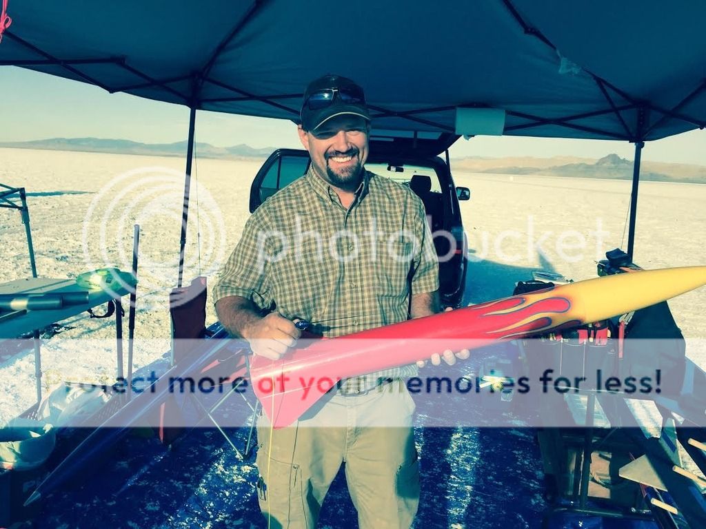
During the UROC annual Hellfire event at the Bonneville Salt Flats, I was most privileged to test out the latest Marshall GPS system. I showed up early to the salt and not long after sunrise, Chet Ferry from Marshall Radio Telemetry showed up looking for a willing volunteer to test out the newest offering. It was a hard sell to convince me:lol:. The product is specifically designed for falconry but they had never been able to test the GPS transmitter on anything faster than a diving falcon. I was tickled to be able to have the unit ride along in the rocket. It's super rugged! All I did was enlarge a hole in the nose cone and shove it in. We had a little length of wire on it so we could retrieve it after the flight. I was a little concerned about a rough ride but Chet said it should hold up just fine. I really wanted to give the unit the ride of its life so I settled on a CTI K600 Classic. That got the rocket moving in short order! If I can figure out how to upload the .gpx file, I will do that and you can look at it in Google Earth. Chet was concerned we would lose lock upon liftoff but it stayed locked on perfectly! I wish we had the return trip with the launch and recovery... Nose cone fell off the rocket and got thrashed around and bounced all over when I was riding the bike back to the tent. Check out the Marshall Radio website here: https://www.marshallradio.com/north-american-falconry-products/gps-systems If you don't look at the price, this transmitter is the cat's meow! Even though I will never afford it, it's still absolutely awesome!
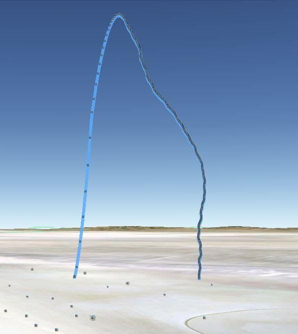
Max altitude was 12675 feet,
Max speed was 894 mph
Total distance traveled was 5.3 miles from start to finish.
Big thanks to Chet and Marshall Radio for letting me test their product and thanks to Chet for the pictures!
K600%20motor%207.31.15_zpsju1xjn8w.jpg

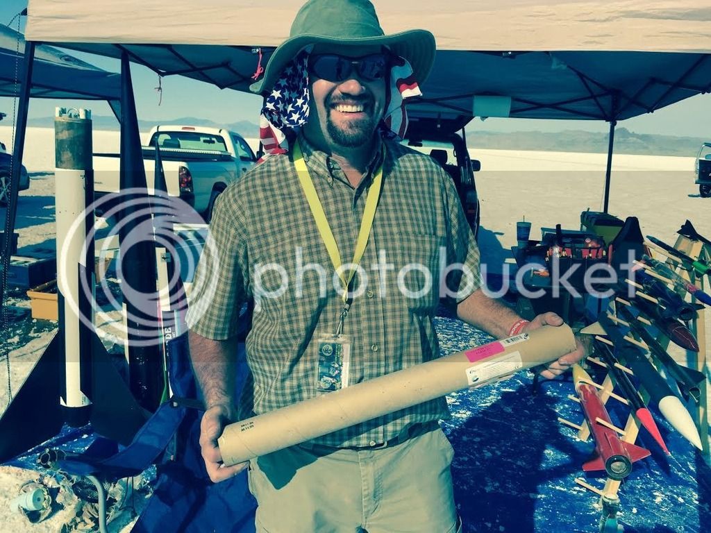
It's really small. I'm holding it in my right hand
Hot%20Rocket%20and%20gps%20transmitter%207.31.15_zpsdiqoyasj.jpg

Pretty sweet flight profile!
Flight%20profile%207.31.15_zpspjmkvpsi.jpg

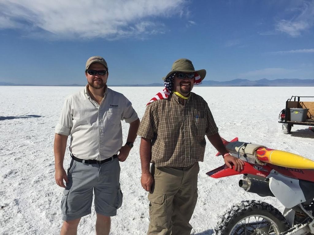
Can't remember this guys name. It's not Chet though!
Rocket%20retrival%207.31.15_zps3ysxgpwy.jpg

-Ken
 
I plan on getting one sooner or later. I saw them on their site a while back and recognized it as something I have to have!
 
Ken, did Chet say what the range of the GPS receiver was? I hate this thread BTW, I have been unable to think about anything else all day long. I love my Marshall TX and RX and I am now very glad I sprung for the 70cm version. To have a GPS and RDF tracker in the same small package is unreal. So sexy.
 
Very impressive device. I've been hoping someone would be moving to downsize a GPS tracker. There are some pretty small GPS receiver chipsets out there. Only issue for some would be the need for a Ham license. The receive station is
a B/T receiver that bonds to the ipad so one would have to make the investment in the Apple devices to make it work. Android is listed "availability and timing to be announced".
Cheaper and smaller than "Kate" but she's still the "Rolls-Royce" of rocket trackers in my book.

I've been toying with an AP510 APRS tracker/transceiver: https://www.amazon.com/dp/B00JLB94IS/?tag=skimlinks_replacement-20.

Though it would only be suitable for larger projects, not acceptable for altitude records, it can be flown with any APRS receiver on the ground or another AP510 could act as a receiver bonded to an Android device with APRSDroid running.
Alternatively, could use a laptop with any APRS tracking program as a receiving station. On the 2 meter band, tunable and 1 watt output so if one puts a good antenna on it inside a long nosecone should get pretty good range at altitude and on the ground.

I've seen data from an aeronaut (balloonist) who flew a 510 alongside a Beeline GPS on a flight just below 40k and even though it's a Sirf 4 chipset, the altitude correlated pretty well with the Beelines Ublox. Never more than 150 to 200 feet off. The chipset works above 60k in the newer units and there are markers in the APRS sentences that attest to that. A "K" is seen which indicates the high altitude ability and "TF" means the
MicroSD card is working. Will write the data to onboard MicroSD at any rate the person wants from 1/sec on up.

The Marshall offering looks very promising and I wish them well. It looks like they'll be able to have an expanded market in rocketry. Falconry might be in the same niche as HPR. I'd probably explore what the GPS chipset is if one is going to be doing 1000knots or going above 60k. If the chipset locks out, might not be worth the investment for speed and altitude junkies. Would be nice to get it altitude qualified for record attempts
'cause records can be broken with smaller, lighter equipment. Kurt
 
Last edited by a moderator:
I called Marshall yesterday and was told the range on the GPS link is somewhere around 30 miles. I confirmed the GPS sends it's location via 70cm to the PocketLink which in turn sends to your iPhone or iPad via BlueTooth. All the while the TX is sending out a 70cm beacon and broadcasting your call sign every ten minutes. So you have a fantastic RDF system backup for close up work. The form factor is only very slightly longer than their UHF TX. I am in the process of convincing the wife this needs to be purchased. I am hoping that if I bug her enough she will eventually give in some time next summer. Wish me luck!
 
I called Marshall yesterday and was told the range on the GPS link is somewhere around 30 miles. I confirmed the GPS sends it's location via 70cm to the PocketLink which in turn sends to your iPhone or iPad via BlueTooth. All the while the TX is sending out a 70cm beacon and broadcasting your call sign every ten minutes. So you have a fantastic RDF system backup for close up work. The form factor is only very slightly longer than their UHF TX. I am in the process of convincing the wife this needs to be purchased. I am hoping that if I bug her enough she will eventually give in some time next summer. Wish me luck!

If she flies rockets you stand a chance, otherwise that's a lot of $$$$ to be raiding from juniors college fund. If you set aside 50 or 100 bucks a month you could get one in 1 to 2 years. Kurt
 
I called Marshall yesterday and was told the range on the GPS link is somewhere around 30 miles.

I wonder how they do that? I can't imagine that the transmitter is putting out much more than a few milliwatts given the available space for a battery. Perhaps the magic lies in an extremely sensitive receiver ?

Greg
 
I wonder how they do that? I can't imagine that the transmitter is putting out much more than a few milliwatts given the available space for a battery. Perhaps the magic lies in an extremely sensitive receiver ?

Greg

I'm a little leary of that claim also but there is this line o' sight calculator they might be considering: https://www.qsl.net/kd4sai/distance.html or this one: https://www.hamuniverse.com/lineofsightcalculator.html

Technically at 500 foot altitude the line of sight transmission is "supposed" to be ~30 miles. With the power output expected at that size through an omni directional antenna, I'd doubt 30 miles. Perhaps with a multi-element Yagi
with no obstructions, with the Yagi pointed at the transmitter while it's still 500 feet or higher, maybe. Once it gets much lower or touches down, I doubt packets will be received at that distance.

Still, I bet there would be utility for rocket tracking and it would be easy(ier) to use in smaller rockets. Kurt
 
Regarding the 30 mile range: In one of the videos on their website they say they put a transmitter on a falcon and then while it was flying around they jumped into a helicopter and flew about 30 miles away in order to test the range.
 
Regarding the 30 mile range: In one of the videos on their website they say they put a transmitter on a falcon and then while it was flying around they jumped into a helicopter and flew about 30 miles away in order to test the range.

I didn't find the video but with both the receiver and transmitter at altitude, would improve the reception range because directly line of sight. I wonder what the encoding process is that's being used but I suspect that may be proprietary.
Could be a known process but they're under no obligation to divulge that information.

I know in Ham Radio there are some digital modes that will carry a long ways on HF for digital transmission like JT-65. Yeah, has to be tied to time code but it's incredible what's being accomplished. Kurt
 
https://www.marshallradio.com/north-american-falconry-products/gps-systems is the Marshal GPS tracker page.

RT-GPS Package : $995 is the cost of GPS tracker, the data converter, and the app for your device.

It also requires FM UHF 500: $895 (Frequencies 434 or 433MHz) which is the matching receiver for the transmitter.

If you want a hard case for the unit it's an additional $145 and a roof top automobile antenna is ~$90.

And then you need a display device for tracking.

The minimum cost of the system is $1890 and will cost over $2100 if fully optioned out with the travel case and car antenna.

https://www.multitronix.com/buy.html is the equivalent page for the Multitronics Kate.

The fully optioned out Kate is $2385, or $2290 if you don't want the turn-on coil. For the extra you get a descriptive real-time audio record of your rocket flight trajectory and a TRA certified official altimeter.

Both systems have pros and cons. The Marshal system is much smaller, lighter and has a 72 hour transmit time. The Kate is specifically designed for rocketry and provides real-time audio altitude, position and velocity information. The Marshal system is a real-time telemetry/beacon tracking system and does not provide rocket function feedback where as the Kate is large and heavy (compared with the Marshal system) and has a much shorter battery life without a back-up beacon.

Both are excellent units, so price should not be the deciding factor as IMO the additional rocketry specific value-added features in the Kate justify an additional $400. If you can afford to build and fly projects requiring this level of tracking, size and functionality, rather than cost will make the decision for you, but it appears you can't go wrong with either one.

Bob
 
Hmmmm,

I thought the Pocket-Link transceiver (the little square box with the antenna) is what handles the receiving chores and the UHF 500 was not required or so I thought. But from their page:

"How much will it cost, and what do we get?
For our customers who have already made the jump to UHF, you simply add the following items to your current setup:

- RT-GPS transmitter
- PocketLink Data Receiver
- Marshall Radio’s mapping software application to run on your iOS device

For customers who do not yet have UHF gear, you’ll also need:

- Field Marshall UHF receiver
- UHF Omni for the vehicle
- UHF Micro tail-mount (recommended as the secondary backup transmitter)

These two lists constitute the ideal and complete, redundant system."

So I don't know. If one can get by without the "long range" receiver or it's not necessary for operation, drop $895 off. Use another antenna and one can cut cost there.

The only advantage over Multironix is the size of the tracker itself. Marshall doesn't have rocket "specificity" though. :wink: Kurt
 
You are correct. I read your response and then read all the Marshal web pages, not just their GPS sell sheet. Shame on me, but Marshal really needs a lesson in writing advertising text because what they posted on their sell sheet page is incomplete, and a bit deceptive to someone who does not already own their products.

1.) The Marshal UHF GPS tracking system is a standalone unit, but that's not the impression you get reading the sell sheet. The beacon tracking receiver is not needed at all for their GPS tracking system which is not what their sell sheet implies, but there is a beeping tracking beacon in the UHF transmitter as well as a data stream, but to utilize this redundant feature, you need to need to purchase their additional UHF tracking receiver. Regardless the Marshal GPS tracking system requires the additional purchase of a cellular version of the I-Pad or the I-Phone with internal GPS software, or in the future a similarly set up Android smart phone for GPS trajectory display so that's an additional $400+ which brings the total cost right up to the Multitronics price for equivalent function.

2.) The ad is actually written to falconry folk who already own the UHF Marshall Beacon falcon trackers. By using their new UHF GPS tracking system in concurrently with their existing beacon tracking system, the falconry folks will have two redundant falcon locating system.

3.) What is not mentioned on the sell sheet is the requirement to have a Ham license to use the UHF GPS tracker.

4.) What is also not mentioned on the sell sheet is the requirement to have a Ham license to use the UHF Beacon trackers as well.

5.) So if you do not want, or have a ham license, this system is not for you.

6.) The license-free 915 MHz Multitronics Kate also can be used as a directional tracker as is for no extra cost.

7.) The Big Red Bee has both 915 MHz license free GPS trackers as well as licensed ham 70 cm and 2 M GPS units for slightly lower prices than Marshal but the units aren't necessarily quite as turnkey, but are nothing that a ham can't figure out. Their high power units have similar ranges to the Marshal units as well, and can be used as a beacon tracker as well.

8.) Both Big Red Bee and Multitronics have documentation of successful use in tracking >100 kft. flights.

https://aeropac100k.insaneprojects.com/Team_AeroPac_2012_100k_Project/100k_Project.html

https://www.multitronix.com/118k-flight.html .

Lots of options.

Bob
 
Yeah, no Android option yet though. There is a mention in some of the Marshall documentation for the need of a Ham Tech license. It's in there but is "sort of" down played. You're right about the expense of the Ipad/iPhone. Have to factor that in if one doesn't have one. Maps? I skimmed the documents and I think one can download and store something for plotting off grid. I would suspect they'd have something of that nature because they have a following in the Middle East where Falconry is popular. Why just make it for the US market only? Wouldn't make sense.

Only theoretical advantage to 70cm and 2M trackers is longer range. For sport fliers who don't expect a rocket to land more than 5 miles away and perhaps < 2miles most of the time, a 915Mhz GPS tracker is more than adequate.

More power output might get you a little more range on the ground but that is not necessarily needed. Get a position packet while the rocket is still 50 to 100' in the air and that will get you close enough to find the rocket or at least receive a new packet for the final resting place if it landed in tall grass or brush. Too much Rf can swamp some deployment electronics to malfunction. Kurt
 
I realize I am in the minority or even smaller but since I already have a Marshall RX, an iPhone and iPad, this is the best GPS solution for me. Having a modular turnkey system that can be put in any of my rockets with little to no special set up is worth the cost for me. All I would have to purchase is the GPS TX and the Pocketlink. For those who get squeamish about the ham thing, the RT-GPS is programmed to spit out your call sign every ten minutes just as my RT UHF does. I have been using the Marshall UHF for while now and I can tell you the performance you get for your money is incredible. They cater to the most demanding customers who could care less about the cost of entry and their equipment shows. It is the Ferrari of tracking systems, I have no doubt their GPS will live up to the same level.
 
I realize I am in the minority or even smaller but since I already have a Marshall RX, an iPhone and iPad, this is the best GPS solution for me. Having a modular turnkey system that can be put in any of my rockets with little to no special set up is worth the cost for me. All I would have to purchase is the GPS TX and the Pocketlink. For those who get squeamish about the ham thing, the RT-GPS is programmed to spit out your call sign every ten minutes just as my RT UHF does. I have been using the Marshall UHF for while now and I can tell you the performance you get for your money is incredible. They cater to the most demanding customers who could care less about the cost of entry and their equipment shows. It is the Ferrari of tracking systems, I have no doubt their GPS will live up to the same level.

You got it made Jarrett having the prerequisites in place. My question would be is the Yagi receiver, UHF 500, a requirement to be able to use it or is it for "assurance" one can get a bearing if the tracker is out of range for a decodable
packet and still receive a pulse for a bearing fix? If the UHF 500 is not a requirement, what is the local range to be expected for GPS tracking? Kurt
 
From what I understand when I called them, the UHF is not necessary but since the RT GPS is a beacon as well as a GPS then you have a back up locator. I personally don't get it really, I mean the receiver antenna on the PocketLink is really short. I know it receives 70cm and not any other mode. It's obviously non directional so it might be one of those things where it picks up great for in flight birds but not so great when they land a long way off. Who knows? By the time I get around to getting one they will be well tested by the bird guys and there will be enough written about them to be comfortable enough with spending the scratch. The real benefit I see to the Marshall stuff is the form factor. I can easily get the TX inside an 18mm body tube. The RT GPS is the same diameter as my RT but slightly longer. This means you could track a 24mm minimum diameter altitude seeker with 100% confidence of getting it back. As cool as Kate is, she can't do that. BTW any thought in getting Kate to say "I am Kate" before the flight? That ought to be good for laugh.

The one thing I can say about their RDF stuff is how sensitive the receiver is and how narrow the receiver works. I can see a bird guy using the GPS to get close and the RDF beacon to pick out a very small and well camouflaged bird in thick cover where the GPS simply won't give you the needed resolution. Not a big deal for the guys out west and their super flat salt launch sites but for an East Coaster that can land in who knows what, that's a big deal. I have used my receiver twice now to find my rocket in cover so thick I was 3 feet from my rocket and couldn't see it. Of course all the other times it has gotten me close enough I can see it 20-30 feet away. I have shown a few curious fliers how well the receiver works by handing them the RX and throwing my TX as far as I can into thick grass then tell them to go find it. They look at me like I am crazy but in a short bit, they come back with the TX and a poop eating grim on their faces followed by the "how much did you say that cost" question. And if you didn't know, the TX is VERY small. I can not say enough good about their products.
 
My reply to the small antenna on the PocketLink is simply see what the connector is and get a better 70cm antenna for it. Could probably interface an Arrow handheld to it if necessary.
I've done well enough with aftermarket 70cm H/T antennas within a couple of miles with Beeline GPS trackers. Get in close enough and get another packet.

I haven't done much RDF tracking in real time but have gone after hidden beacons and up close with a good attenuator and Yagi it's a piece a cake to get right up to it. One way to partially compensate for this is to
use a relatively loud aural beeper or screamer with a GPS tracker...... If the rocket lands in corn, the GPS tracker can get you close and the sound will get you the rest of the way. The ears are a pretty doggone good tracking device.

I launched a two stage modroc with a modified 1st stage on an E9-0/C6-7 combination. Was looking/scanning hard toward the south and my ears caught the sound and I had to swing my head to the north. Caught sight of it and
saw it landed in standing corn and was able to visually gather it wasn't too far in. Sure enough, I started walking in the corn and my ears picked up the sound and led me to it. Kurt
 
Hello!

I would like to receive packets from GPS falconry radio transmitters, e.g. from Marshall and others, to see on the map where falcons equipped with such transmitters fly in the area. (similar to APRS)
As far as I know, they are broadcast on 433-434 MHz and 216 MHz.
Is there any software to decode such signals on windows or raspberry pi with SDR (similar to decoding ADS-B signals from aircrafts and also Vaisala RS41 weather radiosondes)?
Are wav samples of these signals available in raw form (discriminator)?
 
Hello.

I need raw signal samples from the Marshall RT-GPS 433/434 MHz transmitter that caught a fix and sends radio signals.
Such samples can be recorded e.g. with an SDR dongle (audio filter turned off) and saved in a PCM .wav 48kHz 16 bit file

A page with such signal samples can be found at this link:
https://www.sigidwiki.com/wiki/Category:UHF
Unfortunately, Marshall and other brands' falconry GPS telemetry is missing.
 
Have you contacted Marshall to see if they have the communication specs for their transmitters? My guess is it is likely proprietary. A friend has the system and it's very impressive. I can see though why they would want to keep it to themselves and not want random people tracking falcons that are not theirs. Especially given the popularity of the sport in certain parts of the world where that may present a security issue.


Tony
 
Back
Top