New tracker range test result

The Rocketry Forum

Help Support The Rocketry Forum:

This site may earn a commission from merchant affiliate links, including eBay, Amazon, and others.
Just food for thought but I really like standalone trackers. Primarily because I am starting to fly more carbon fiber rockets and have been mounting the trackers in the fiberglass nosecones. I also think it simplifies things to have them separate. I know some will say that's just the opposite but I want a tracker I can move between rockets that may have anything from my original RDAS Compact (or even an earlier PML Co-Pilot) to one with a Raven and Statologger CF combo (my favorite redundant setup). It's nice to be able to have a several rockets setup with a variety of altimeters and just move a tracker between them.

But I do understand folks who want an all in one unit. An ideal solution of course would be to offer it both ways, stand-alone and as a complete unit.

There is a current BALLS thread with weather here:

https://www.rocketryforum.com/showthread.php?66850-So-maybe-I-ll-try-a-three-stager/page17

I linked to the last page as it has the most up to date info.

Good luck at BALLS,


Tony
 
I've been working on something similar for a while now, though yours is by far more polished than mine and at a much smaller footprint... and I have no app.....and my ground station is huge by comparison.

[YOUTUBE]RWzlSlwZqlI[/YOUTUBE]

LoRa works great. I tested my unit at Airfest on 30mW of power and collected 90% of the packets. Mine was on the 70cm ham band (KK4ELF) and I used a 5 element Yagi to receive the signal.

The most I could get is 5Hz for the data rate, but I send quite a bit of data in each packet (velocity, altitude, acceleration, 3-D rotation, GPS lat/lon, flight computer event status, callsign). I also log it to an SD card. Like you, I was very concerned about a ballistic recovery and no data to troubleshoot.

Ublox is definitely the way to go. I used the GPS unit Adafruit sells and had all kinds of problems.

Magnetometer data is a nice touch. I used the signal strength and altitude to home in on the bearing and azimuth during descent. It was gratifying to call out "mains deployed" and then see it over a mile away in exactly the direction I was pointed.

Eventually I will use a bluetooth connection to send data to a smartphone, but I'm no app developer. I hand-jam the coordinates into the phone. One problem I did have was lack of a cellular data signal. I couldn't get Google Maps to work until I found one. Having some pre-loaded maps on the app (or some other workaround) would be helpful.
 
I'm impressed Bryan. It's great to be able to call out the direction and have eyes pointed at the expected main deployment. If the rocket is small in stature and/or very far out, one won't see it. At 1.5 miles and a 36" main chute one might not see a thing. But it's reassuring you know you have a great starting point
for the recovery. I'm intrigued by the low power and long range reception. It was interesting how the commercial and pricey RDF units got the range at least in the air with low power and changing the modulation of the signal. It's nice to be able to get long range out of low Rf output.

The only thing needed is a last position just before loss of signal (LOS) so one can be put into the ground footprint of the tracker. If it's not seen at least one gets
a new position fix to the final landing position. Kurt
 
Quick post from a cellphone before I head back to the playa. The tracker did well today, returning data from over 137,000 feet on Doug Krohn and Sean Serrel’s big 2-stager today.
 
Collecting 90% of the packets via Rf? That's incredible. That data stream is begging to be piped to a mapping application.

Sparky, get yourself a used Nexus 7 2012 or 2013 3G or LTE. Can track live with GPS Rocket Locator. The Apple ios stuff is not amenable to user developed apps. Hand crunching is fine as long as one doesn't screw up the units but automatic tracking and navigation is really sweet. Kurt
 
Really great to hear Adrian. Looking forward to seeing a final product. Great to have another option on the market, especially one that works with iOS. Thanks to you and all the other vendors who take our hobby seriously.


Tony
 
Collecting 90% of the packets via Rf? That's incredible. That data stream is begging to be piped to a mapping application.

Sparky, get yourself a used Nexus 7 2012 or 2013 3G or LTE. Can track live with GPS Rocket Locator. The Apple ios stuff is not amenable to user developed apps. Hand crunching is fine as long as one doesn't screw up the units but automatic tracking and navigation is really sweet. Kurt

Yep, that was my intent all along. Just couldn't get there before Airfest. I'll play around with Bluetooth over the winter and see if I can get it to work. I may work a GPS unit and compass into the ground receiver. Or I might just tie into the ones onboard the Android device.

The great data collection rate speaks to how good the LoRa units are. My flights at Airfest collected >95% of the packets. I'm going to be using this unit in three of my rockets at MidWest Power in November.

Yeah,

Messed around with 3DR in another thread and got introduced to GPS/Glonass monitoring. Got to where I could get around in the Ublox UCenter utility and found out the
$6.25 Ublox-m8N clones are not exactly the same. Was able to configure the cheap clone to monitor GPS/Glonass strings and of course UCenter can display it on a Google
map:

ALL3.jpgALL.jpg

Picture on the left is the US GPS constellation only and it was in a favorable configuration tonight. A hand grenade through a window could'a got me. On the right is the raw GPS/Glonass
input coming in over the same clone -m8N chipset through an FTDI/USB serial card indoors. I can turn Glonass on or off at will through UCenter. Left pic, Glonass off/GPS on, right pic GPS on/Glonass on being used for positioning.

Bottom line is combined monitoring is a bit more accurate but plain jane GPS will get one pretty dern close. I know I got a ballistic rocket fincan out of the ground with good 'ol USA
GPS only. Combined monitoring is icing on the cake and if Adrian is going with that, I bet he'll set the new benchmark and can grab some more customers for those that desire a bit
more.

Only potential problem I've found so far on Android with "GPS Rocket Locator" is it cannot handle GPS/Glonass strings together worth squat. I have an Eggfinder with a "True" Ublox
GPS chipset with a passive Sarantel Quadrifiler antenna (the source of the pictures above) and GPSRL CANNOT decode the combined GPS/Glonass strings. Instead, I've found if one uses
the Android utility "Bluetooth GPS": https://play.google.com/store/apps/details?id=googoo.android.btgps&hl=en Run it, minimize it and start "GPS Rocket Locator" and allow "mock locations" the "blue dot" will be the rocket location. The internal GPS is ignored on one's phone or device. The rocket location gets piped to GPSRL as the "local", blue dot location.
Get an external Bluetooth GPS source and there are a pile of them: https://www.ebay.com/itm/Great-cond...482547?hash=item1a1c17f7f3:g:T1YAAOSwLF1X3ngX bond it to your device and velcro the thing to your ball cap! Open GPS rocket locator and in the setup select the Bluetooth GPS you have bonded. Now the red pushpin will be "you" and the blue dot will be your rocket.

You hit "track me" and GPSRL will "track" the blue dot which is now the rocket and I find that highly desireable. Remember, the red pushpin is now "you" and not the rocket.

I've tried inputting the combined GPS/Glonass strings into Ham radio tracking apps and no cigar no matter what under WinBlows. Kurt
 
Last edited:
Adrian will be back soon to tell us about some more awesome data. :) 137k ft range with just 25mW is pretty awesome.
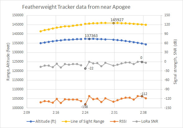
 
Here's more detail on Sean and Doug's flight near apogee.

A5Xqial.png


The data in the graph comes from playing back a video screen shot I took on my phone during the flight (thanks, iOS11 update) and manually entering the data points. In the future we will record all the data that get back to the ground into a data file.

This flight was done with a stubby omni-directional antenna at both ends of the link, the same one in the pictures of the ground station up-thread. For the data shown, I was holding the ground station above my head with the antenna perpendicular to where the phone told me the rocket was. The transmitter in the rocket was duct-taped to 3/8" steel all-thread that was running down the center of the nosecone, and the tracker was mounted just above a set of 4 GoPro cameras running their WiFi radios. The all-thread was parallel to the antenna and about 1/2" away. Because of the installation, the rocket's antenna was pointing away directly away from the ground and was shielded by the camera cluster for the first part of the flight. This may not be a worst-case installation RF-wise, but it's pretty close. This tracker was a last-minute addition to the rocket, which used a Big Red Bee for its primary GPS tracking system. (Thanks for letting my fly with you, Sean and Doug!) Anyone integrating this tracker into their rocket with a little planning to keep metal away from the antenna should be able to get radio performance better than this. Shortly after liftoff I noticed that my phone had disconnected from the ground station and I had to manually reset them and re-connect (in the future this will be automatic). I didn't get everything back on-line until the first data points you see here.

The output power was 14dBm (25 mW), which is the highest output setting for the the high-efficiency power amp in the radio. The radio also has also a higher power amp that consumes a lot more juice for an additional 3dB (continuous) or 6dB (1% D.C.). I haven't tried those out yet, but I may make them a part of an adaptive rate protocol I'm working on. The LoRa spreading factor was 11 and the bandwidth was 250 kHz. With those settings, the expected receiver sensitivity is -128.5 dBm for a 1% packet error rate. The RSSI (received signal strength) data in the graph above has typical values of around -128dBm, but of course it fluctuates with the orientation of the ground station and probably with the points in time when the all-thread was in front of the antenna. So the receiver sensitivity seems to match predictions. The gradual improvement in signal strength in the plot above is likely due to the rocket arcing over and giving the ground station a better view of the side of the antenna. The expected signal strength at the receiver for a range of 145,927 feet is -110.6 dBm if both antennas have 0 dB gain. So there is about 18 dBm missing in the received signal strength, very likely because of non-ideal alignment and blockage of the transmit antenna, misaligned polarization and partly due to some losses on the board.

In addition to the RSSI data, the LoRa radio also provides an indication of signal-to-noise ratio. Here's where the LoRa magic comes in, because with a signal-to-noise ratio below zero, a normal radio would not be able to recover the packets. The LoRa modulation uses a lot of RF symbols for every data bit (as many as 4096), and that voting process allows it to decode weak signals at the expense of slower data rate. The tracker application doesn't need a high data rate, so this is perfect for us. From what I can gather and from the behavior I have seen, the reported SNR is an indication of how much disagreement there is in the redundant data. For strong signals, it never shows anything larger than 6-8dB, which I suspect means that all the redundant RF symbols are in agreement with each other. But for these settings, decoding a packet is possible when the SNR is as low as around -25 to -30 dB. In the small sample above, there were a couple packets with SNR at -22, and the average was around -12. So there was some room to weaken the signal by 10 dB or so and still make the link. 10 dB loss translates to a factor of sqrt(10) in range, so if this rocket had gotten up to the edge of space, we would have seen at least a few packets from there.

The GPS also did well, and all the data was consistent. Some minor kinks in the plots above are artifacts of 1 second resolution on the video file and different data points updating at different times. The last packet had GPS data accurate enough to put us right on top of the rocket for the recovery.

On Sunday we flew Kevin Small's minimum-diameter rocket on an M and recovered the whole 10 Hz GPS output that's recorded on board, so that's a better flight for looking at the GPS performance in-depth. I'll post more info on that a little later.

All in all, here's how I feel about the LoRa radio performance on this flight :marshmallow:
 
Adrian will be back soon to tell us about some more awesome data.

See!?

Wow, I figured the 137k was slant range. That’s a heck of a flight to be able to ride along on for testing. Thanks for all the info. Awesome stuff!

Edit: It’d be great if this tracker recorded data onboard so that we could have a full reconstruction after landing. It’d also be awesome if this was available as an option for TRA record flights. ;) EDIT2: Oh, there it is. I missed that you talked about it being recorded at 10Hz on the board. Sweet!
 
Last edited:
One other interesting thing is that the rocket came in ballistic. but with the last transmission combined with the heading and horizontal and vertical velocity (included in the transmission), they could compute the impact point and still pretty much walk to the rocket in the ground.... :)
 
Adrian has probably set more records than anyone. I’m sure he was already thinking about it...just wanted to voice my request.
 
See!?

Wow, I figured the 137k was slant range. That’s a heck of a flight to be able to ride along on for testing.

Yeah, those guys have been going after that kind of performance for a number of years now, and they built 2 complete rockets for the weekend. The first one on Friday had a sustainer issue at burnout not long after I arrived on the playa. Friday afternoon we figured out how to include my tracker for their 2nd rocket which they flew on Saturday. I'll be interested to find out if it was the highest flight of the weekend. For sure I was lucky to get a chance to send the tracker on a ride like that, and with how it turned out they were happy that it was on board, too.

Edit: It’d be great if this tracker recorded data onboard so that we could have a full reconstruction after landing. It’d also be awesome if this was available as an option for TRA record flights. ;) EDIT2: Oh, there it is. I missed that you talked about it being recorded at 10Hz on the board. Sweet!

So far it's just designed for the Sparkfun OpenLog to be soldered to it with a header that goes along the side, and that has been getting the job done. I have been leaning toward just continuing with that. It's not as mechanically robust as having it all on one board, and the recurring cost is higher, but it's less software development this way and it helps it keep the board footprint smaller. I think that will meet the intent of the Tripoli record-certified GPS trackers, but I don't know for sure.
 
Really great report, thanks for writing it up. Sounds like you have a very useful system. Looking forward to more details about pricing, availability, etc.


Tony
 
So far it's just designed for the Sparkfun OpenLog to be soldered to it with a header that goes along the side, and that has been getting the job done. I have been leaning toward just continuing with that. It's not as mechanically robust as having it all on one board, and the recurring cost is higher, but it's less software development this way and it helps it keep the board footprint smaller. I think that will meet the intent of the Tripoli record-certified GPS trackers, but I don't know for sure.
OpenLog is great like that. From the talking I've done with them, it seems like that'd meet the intent - as long as the ability to record data is a commercially available option and you get them some data from some flights. They'd, of course, be able to give you better info.

Thanks for working on this. Having a small LoRa tracker available means that I won't have to make & sell my own. More time for building rockets! :)
 
One other interesting thing is that the rocket came in ballistic. but with the last transmission combined with the heading and horizontal and vertical velocity (included in the transmission), they could compute the impact point and still pretty much walk to the rocket in the ground.... :)

Many folks have already pointed that out with their own ballistic flights using GPS trackers. Walked up to a fincan pointing up myself. It is really the way to go now. I believe if the device is provided with a permanently attached onboard memory,
then the respective organization's boards could be petitioned for its use in record attempts. Kurt
 
Great work everyone.

How about having an estimated impact point on the ground that updates as the flight progresses :)

Funny thing - when Adrian told me about the first test flight (his flight Sept 17th in Colorado where Adrian undersized the ejection charge on and it came in ballistic), my reply text was literally "Sounds like we need a page [screen] for "projected impact point"... ;-)"
 
Great work everyone.

How about having an estimated impact point on the ground that updates as the flight progresses :)

If the rocket is coming in ballistic, all one needs is one position from a couple of hundred feet up. Point of impact is pretty near and straight down.
Now if your last position was just after apogee and there are wild upper air winds, point of impact could be anywhere and a simple ballistic prediction
could be way off.

And of course, depends upon the nature of the flight (ie. 137,000 feet?) and reception of the position on descent. Get a few positions close to terra firma
and you got it made whether or not there is a real time calculation algorithm or you just walk to that location. Kurt

The two ballistic flights that I have tracked in the last few weeks both had packets close enough to the ground that extrapolating from the last packet with some mental math put me right on the impact point. For one of those (my 38mm L1 re-cert attempt) the impact was invisible after about 5 minutes of searching from the last packet ground location before I did the mental math. So I think of this as a convenience feature, but for some people or some flights it might be the only way to get the rocket back. As long as we're at it, we could compute the parabolic trajectory rather than just assume linear extrapolation from the last point, which could be needed if there is a loss of signal closer to apogee for some reason. It would be nice to at least make it user-selectable to track to that point rather than the last packet location. For a nominal recovery where the transmitter is still operating, the two locations should become the same again once you get in range to get a new packet from the ground, since the reported velocity will be zero.
 
The two ballistic flights that I have tracked in the last few weeks both had packets close enough to the ground that extrapolating from the last packet with some mental math put me right on the impact point. For one of those (my 38mm L1 re-cert attempt) the impact was invisible after about 5 minutes of searching from the last packet ground location before I did the mental math. So I think of this as a convenience feature, but for some people or some flights it might be the only way to get the rocket back. As long as we're at it, we could compute the parabolic trajectory rather than just assume linear extrapolation from the last point, which could be needed if there is a loss of signal closer to apogee for some reason. It would be nice to at least make it user-selectable to track to that point rather than the last packet location. For a nominal recovery where the transmitter is still operating, the two locations should become the same again once you get in range to get a new packet from the ground, since the reported velocity will be zero.

Me, I had a live map and wondered out to the spot referring to my map that I had zoomed in. Was a short rocket so with the cornstalks in the harvested no-till field, the fincan was close to the ground. I didn't take the obligatory pic because I was afraid it
would screw up the program I was using. I walked back and forth twice and didn't have anything to mark the site. (Had to go back and get a shovel) That's the reason I didn't want to disturb the program. Didn't want to lose the last known position that got me to the rocket.

21000002.jpgScreenshot (8).jpgScreenshot (5).jpg

The ballistic rocket is on the left with the burn hole that occurred after I replaced the black NC with the red one. The photomap tile to the extreme right is the initial plot out there. I wondered around a bit initially.
The middle plot was a second instance that captured my walks back and forth to the burial site. Dug out the rocket. If I had had the time, I wouldn't have trashed the nosecone getting it out. Had to go back and forth to get the shovel.
The burn hole happened on a motor failure on another flight. Slid down a coupler and the rocket still flies and works well as a tracker dog. Kurt
 
Kurt, Your post has bits of wisdom in it for application / UI design so thank you for the inputs / feedback!
 
wow, talk about thread drift....


Tony

Yeah Tony but what Adrian is doing is parallel with what I've observed with combined GPS/Glonass strings. If he comes up with a live mapping app, all the better. If not and he
can only get the GPS/Glonass strings piped off over USB or Bluetooth, might be wise to have a means for the end user to shut off Glonass and use the USA GPS alone. Kurt
 
Kurt, Your post has bits of wisdom in it for application / UI design so thank you for the inputs / feedback!

Hi Kevin, I've been trying to keep my eyes open for an easy live mapping tracking solution for everyone since I became a Ham in 2007. The ISM trackers on the 900Mhz bands offer
the option for tracking for folks without a Ham ticket. To achieve the end of live tracking on a map with one's local position, the rocket's position plus recording and saving the Rf acquired
positions for perusal and comparison later along with a live navigation to the downed rocket is not so easy. There is stuff out there that will plot the rocket live but won't keep track of you.

The Ham radio APRS stuff can do it nicely and plot on a map. NMEA, which is what the Eggfinders, Missileworks and I expect Adrian's "project" is, it's a different story.
"GPS Rocket Locator" is the easiest app which is on Android for a neophyte to use bar none. Not the greatest as far as presentation and storage of data but it will help
one find their rocket. Get the two dots, blue and red pushpin to come together and one has it made. Can cache photo map tiles so far so online access to maps is not
necessary and if no map can be had, north is "up" and can make the two dots come together on a blank screen.

Those two pictures in post #57 on the right were with a "hacked" Ham radio app APRSISCE/32 on Windoze. One tracking the rocket, one tracking the local position and communicating
with one another. Doesn't work the way I like so I'm going to test with "just" tracking" the rocket flight until the rocket is down and then "turn-on" the local position so it gets placed on the
map to the walk out to the last known position. With both apps running at once, I suspect I am missing in-flight positions due to latencies with running two programs that communicate with each other and asynchronous data collides. Oh, that was the ballistic flight so not so many positions were "seen".

When I say "hacked" it's not changing the code in the software but just some user accessible parameters to get it to work. When I posted my dilemma in
the APRSISCE group about monitoring two NMEA streams, I bet is wasn't more than 3 hours before a fellow posted a way to get it done using two instances!

Only thing I'm pointing out is if GPS/Glonass is going to be used, one needs to be aware some of the standard apps out there can't handle the combined position
strings. Kurt
 
Back
Top