New tracker range test result

The Rocketry Forum

Help Support The Rocketry Forum:

This site may earn a commission from merchant affiliate links, including eBay, Amazon, and others.

Adrian A

Well-Known Member
TRF Sponsor
TRF Supporter
Joined
Jan 21, 2009
Messages
3,152
Reaction score
2,795
Location
Lakewood, CO
I have been working on a GPS tracker for the last 8 months, and I finally got far enough with the system to do a little range test. I set up a tracker radio in my backyard in Palo Alto, and then headed to the San Jose airport for my flight to Denver, where I work. Once the plane took off, I held up one of my radios representing the ground station to look out the window. I was getting packets while the distance to my backyard was 62kft until the plane banked away. The transmitter on the ground was set for 14 dBm output, (25 mW) and both radios had simple omnidirectional stub antennas. Considering the trees and houses near the transmitter I'm not sure that I had a clear line of sight to the plane. I know the receiver looking out the window had a view to every 915MHz transmitter in silicon valley, so I'm happy that it could pick my transmitter out of the noise. I'm looking forward to testing with some rockets transmitting from a clear sky, particularly at BALLS next month.

When I get a little farther with the firmware and testing I'll give a complete description of the product. I've been trying to avoid announcing anything until I got far enough along to be sure that the tracker and ground station would really go into production. I'm not quite at that point yet but I couldn't help but say something today since today's test was pretty encouraging. :cheers:
 
12 miles on 915MHz and 25mW, nice! How did you calculate the distance?
 
12 miles on 915MHz and 25mW, nice! How did you calculate the distance?

Thanks. The goal is to get get as much range as anyone could want, while still using small batteries and antennas.

I used a GPS app on my phone that was navigating to a waypoint at my house. Soon I'll be able to use my own GPS but that part of the software isn't done yet.
 
Increasing efficiency is a very good goal so GPS tracking can be put into smaller and smaller projects. Saves on losing rockets and if used, the pricey reusable motor casings. I've been leary to fly some of my small AT casings due to fear of losing the
rocket/motor casing. Kurt
 
As a heavy user of a variety of your products I'm looking forward to seeing what you've got. The more choices we have the better for all involved. Great that so many folks are willing to develop products for such a small hobby.


Tony
 
Thanks for the update Adrian! I'm looking forward to learning more. :)
 
I've been waiting for this update. :) It's great to hear about the progress! I'm looking forward to trying one out one day.
 
Thanks, guys.

I've been waiting for this update. :) It's great to hear about the progress! I'm looking forward to trying one out one day.

We have been waiting a long time. Since I started last winter I had to change the main microcontroller and development environment (twice), the radio module, the GPS module (twice), the "other" radio module. Finally all the pieces are solid and the firmware and testing is coming together. Basic functions should be ready and flight tested in time for BALLS. Production features like over-the-air bootloading for firmware updates, low power modes, and some cool other functions will be after that.
 
Is it just me or is anyone else sensing an increased heart rate while reading this ?

Im stoked !!!

I know Christmas is coming in a short 4 months.. or has it arrived today ?

Sleigh bells ring, are you listening, In the lane, snow is glistening A beautiful sight, We're happy tonight. Walking to our rocket via GPS.....

Cool :)
 
Wow! I thought my commute from Gilroy to Santa Clara sucked. :)

I'm interested to see your tracker make it to market. More options are always welcome.

I set up a tracker radio in my backyard in Palo Alto, and then headed to the San Jose airport for my flight to Denver, where I work.
 
Today the Featherweight Tracking System had a successful test in its first high-powered flight, so here's a little more info.

I don't have a good photo of the tracker itself, but I'll post one after I assemble one without the extra debug header pins. The dimensions of the production tracker board will be about 0.82" x 1.62". So it's a little smaller board than a Raven altimeter in both dimensions, despite having mounting holes for 4-40 screws. The 900 MHz stub antenna adds about 2.5" to the length if you mount it right to the board.

The tracker collects GPS data with a brand-new 8th-generation uBlox receiver that can receive data from both GPS and Russian GLONASS satellites at the same time, and integrate data from both constellations into its solution. The benefit is that for a given antenna field of view, twice as many satellites are available as for any GPS-only receiver. The testing I have done so far with this receiver has blown me away with how clean and accurate the data is, even in altitude and vertical velocity, which have been not-so-great with other GPS receivers I'm used to. I'm currently having it produce and record 10 GPS solutions per second, and in a test case where I pick the receiver off the ground and wave it around, you can clearly see that in the altitude and velocity data. There's less than 1 ft/second of measurement noise in all 3 dimensions.

The tracker sends its data from the rocket down to the ground over a new protocol called LoRa (portmanteau of Long Range), which is a new commercial standard from Semtech optimized for sending small amounts of data over long range at very low power... in other words, tailor-made for rocketry GPS tracking. I'll post more details about the link performance later after I do some more range testing, particularly after BALLS next weekend where it will see some high-altitude flights.

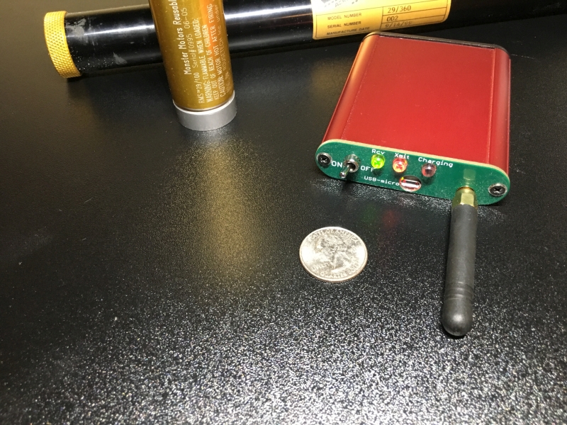
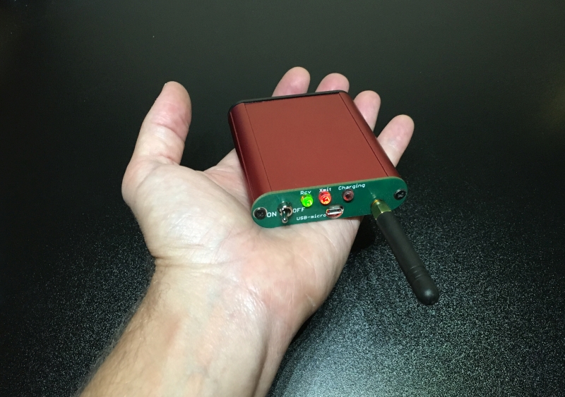
To get this LoRa data into information you can use, there is a small ground station that fits in your shirt pocket, and relays the data to an app on your cell phone.

5bBAtnL.jpg

HXUKjNQ.jpg


The micro-USB port is just for charging the battery (8-40 hours of life depending on battery size). The tracker sends out the data over Bluetooth Low Energy to an app on your phone.

We have been focusing on the iPhone app so far, since Android-compatible trackers already exist, but the plan is to make an Android version soon, too. During the flight, the app not only shows you the key information like altitude, vertical and horizontal speed and distance, but also has some real-time indicators that use the GPS, magnetometer and gyroscope in your phone so that you can use the phone to point right at the rocket. Kevin Small (author of the Featherweight Interface Program) has been working on the the app development, and came up with this. At first I was skeptical about how useful this would be, but when you try it and see the phone pointing right to where your rocket is in azimuth and elevation, it's pretty impressive. I'll show a screen shot once we get it a little farther along.

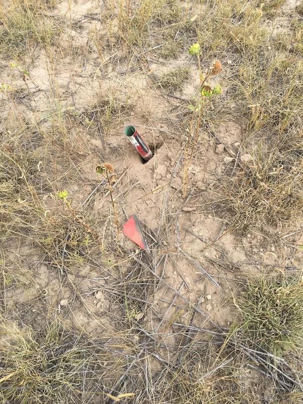
In today's test flight, I was trying to not only test the tracker and iPhone app (the first version of which I only downloaded last night!), but also to get re-certified L1 since my HPR certs have expired. Just about all of my HPR flights to date have been designed to be as high and fast as possible, so I decided to go big and use an AT I600 in a minimum-diameter 38mm rocket for my cert flight. Unfortunately, I neglected to ground test my deployment charges before the flight, and they were too small, so although the rocket had a sweet boost around Mach 1.3 up to 11,400 feet, it had a ballistic re-entry 1.2 miles up-wind. One of the features we're planning but have not yet implemented is data recording from the ground station. I did have 10 Hz data recording onto a micro-SD card on-board the rocket, but that's not so useful when a 4-foot long rocket's landing site looks like this:
MO8QhaG.jpg


Sorry, my rocketry skills are rusty. (Ground test, ground test, ground test!) My recollection from watching the phone display is that both the LoRa radio and the GPS kept lock throughout the flight, but confirming this impression will need to wait until next weekend's flights at BALLS. But what I can tell you is that the last packet that got to my phone was 6321 feet away from my phone, 448 feet above the ground, traveling -540 feet/second vertically and 52 feet/second horizontally. There was about 36 dB of radio link margin at this range and with these settings. When I hiked out to that latitude and longitude, sure enough the rocket tube was sticking out of the ground about 40 feet downrange of the last measurement report, just as you would expect from the horizontal velocity. So the last data point for tracking was right on the money.
 
Adrian, this is outstanding. It’s awesome to see the new standard in trackers getting close to market. LoRa & UBlox 8 is the combo to have. Woot!

Sorry about your rocket & death of a prototype tracker. That hurts.
 
I will attest to that. Working on a 3DR solution: https://www.rocketryforum.com/showthread.php?141685-25-GPS-Solution/page9 but I am a script kiddie
and not an engineer. I used an -8N clone and found that my usual hacked ham apps couldn't deal with the combined GPS/Glonass strings but if I
ran the combine strings through the Android app Bluetooth GPS I could pipe the strings to an app and get them read and plotted. It is indeed
more accurate. Being a Ham, I'd like to see about getting a callsign in the NMEA strings to maintain legality.

3DR is two way and we really don't need that. A 500mW solution on 70cm would go a long way. Working with 900Mhz with 3DR is stupid unless one
wants to tinker. There are many commercial offerings and now Adrian has a promising one on the way.

I was impressed with testing with my hacked system but this looks much nicer and GPS/Glonass decoding is pretty darned good.

Suffice it to say, I and many others have not lost a fully functioning GPS tracked rocket with the standard GPS tracking standard. (Barring landing in
an inaccessible place!)
Kurt
 
A few more questions

Will you need a ham license for this?

What sort of price range are you anticipating?
 
Thanks Tony.

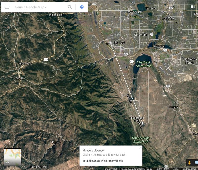
A small update. I was getting ready to try out some longer-range settings in preparation for tracking rockets to over 100,000 feet at BALLS this weekend, so I started by doing a range test with my current setup. I taped a transmitter to the window at my lab at work, and drove to the furthest accessible spot with a clear line of sight, which is 47690 feet (9 miles) away. I was reading packets with 18.5 dB of signal strength margin, which means that I could have gotten data from 439,000 feet. :surprised: That altitude would be beyond the edge of space with over 100,000 feet to spare. I guess I don't need the change the settings after all. :cheers:

WgnZUqF.jpg

Adrian, I am excited to see this. I am also excited by an app that will work on an iOS device. What are the dimensions.


Sent from my iPhone using Rocketry Forum
 
Adrian, I am excited to see this. I am also excited by an app that will work on an iOS device. What are the dimensions...[/url]
Not to steal Adrian's thunder but he lists the dimensions above:

"The dimensions of the production tracker board will be about 0.82" x 1.62". So it's a little smaller board than a Raven altimeter in both dimensions, despite having mounting holes for 4-40 screws. The 900 MHz stub antenna adds about 2.5" to the length if you mount it right to the board."

I've worked with Raven's for years due to their very size size and if the board for this is smaller than a Raven, it's going to be extremely versatile. I'm also very excited to have a native iOS app. A dream app would be something like MotionX for rockets.

I'm hoping that BALLS weather cooperates and Adrian gets to do some good testing. Really looking forward to some high altitude real world tests.


Tony
 
LoRa FTW!

Exactly.

Very nice Adrian. You'll make a lot of long range tracking folks very happy. Kurt

Thanks, Kurt. You've been doing great work here on the DIY end of things.

Adrian, I am excited to see this. I am also excited by an app that will work on an iOS device. What are the dimensions.

0.82" x 1.62" for the board, not including the antenna or antenna connector. I may want to make a whip antenna variant so I can squeeze one into a 38mm Featherweight Av-bay next to a Raven and stick the antenna out a little hole. Then I can fly it in my 38mm altitude record attempt rocket and get back into 38mm multistage altitude shots.

Is this a tracker only, or will it be available paired with an altimeter on the same board?

What I'm testing now is tracker-only, with some hooks to share data with a possible future altimeter. The unused pins on the tracker's microcontroller are calling to me, though, (Use me!... Use me!!) and the GPS may turn out to be good enough to make a baro sensor unnecessary, so I'm giving some thought to making a combined unit for the next product.

I've worked with Raven's for years due to their very size size and if the board for this is smaller than a Raven, it's going to be extremely versatile. I'm also very excited to have a native iOS app. A dream app would be something like MotionX for rockets.

I'm hoping that BALLS weather cooperates and Adrian gets to do some good testing. Really looking forward to some high altitude real world tests.
Tony

We're starting with iOS because there's a niche to fill, and also because I like my iPhone. Android will be coming too, though. I use MotionX and the new app will have some of the features of its compass. For mapping initially we will probably have it help you to send the coordinates to another app.

I checked the BALLS weather forecast today and it looks kinda chilly but otherwise great. I haven't checked the jet stream for wind shear predictions yet, though.
 
Back
Top