You are using an out of date browser. It may not display this or other websites correctly.
You should upgrade or use an alternative browser.
You should upgrade or use an alternative browser.
Hurricane Matthew is about to visit the Space coast
- Thread starter JTH28890
- Start date


Help Support The Rocketry Forum:
This site may earn a commission from merchant affiliate
links, including eBay, Amazon, and others.
My son Noah is (was) currently training at Parris Island, SC and is three weeks from graduation from Marine Corps boot camp. He is one of 6000 recruits that they just evacuated inland to Georgia.
USAFmissileer
Well-Known Member
- Joined
- Aug 6, 2014
- Messages
- 587
- Reaction score
- 12
My daughter attends Flagler College in St. Augustine and went with her roommate to Valdosta, GA. Praying you all are safe!
Mike
Mike
blackjack2564
Crazy Jim's Gone Banana's
My house in the path..Savannah Ga. Expect 70-80 mph winds on my street, I'm downtown, 14 miles from beach.
If lucky the eye will pass 20- 60 miles off shore then turn and go out east ..but now it might swing around and go back to Florida where it could hit landfall again.
All those east of I-95 mandatory evacuation. That's the ENTIRE city. Expected storm surge, even if storm passes us is 9-11 ft. Most of the city barely above sea level....I'm 34 ft. Main road from beaches...islands east coming through city is ONLY 2ft above sea level and 12 miles straight through nothing but marsh, over 100,000 living out there with just that 1 road. At normal high tide road bed has water lapping up to it just feet away!
It will be 7-9 under water.
The fun begins ....here's a link to our local Hurricane hot line weather for those wanting to keep up with real local report.
This week was our annual Pirate festival 5 day of talk'n like a Pyrate. Over 25,000 already at Tybee beach where the parade & activities happen....all had to leave!
https://www.wtoc.com/weather
All roads coming in closed at noon today. Now all lane converted to exit direction. This is the largest evacuation in modern times over 28 million displaced in Florida- Georgia -South Carolina-North Carolina...now the big question.
Where they all going ?
Last time this happened '99... so many cars on I-16, they turned it into a 385 mile long parking lot. That's how far to Atlanta and that's how far traffic was backed up with no where to go! Sitting there running out of gas after hours & hours of not moving in the hot sun with AC running. There thousands of cars abandoned along the entire run.
Even a year after there were still several hundred abandoned that no one came back for, which they finally towed & auctioned.
Oh well maybe we'll get lucky and the damn thing will go find Toto & Dorthy.......
CzTeacherMan
Well-Known Member
- Joined
- Aug 8, 2014
- Messages
- 2,982
- Reaction score
- 171
Stay safe everyone!
- Joined
- Jun 27, 2012
- Messages
- 5,439
- Reaction score
- 121
Well I'm still here. All went good not much damage. power is back on. Did the drive around town thing lots and lots of damage.
I wonder if the VAB would be easily damaged in a hurricane?
Screaminhelo
Shade Tree Rocket Surgeon
- Joined
- Jan 30, 2013
- Messages
- 935
- Reaction score
- 4
My house in the path..Savannah Ga. Expect 70-80 mph winds on my street, I'm downtown, 14 miles from beach.
If lucky the eye will pass 20- 60 miles off shore then turn and go out east ..but now it might swing around and go back to Florida where it could hit landfall again.
All those east of I-95 mandatory evacuation. That's the ENTIRE city. Expected storm surge, even if storm passes us is 9-11 ft. Most of the city barely above sea level....I'm 34 ft. Main road from beaches...islands east coming through city is ONLY 2ft above sea level and 12 miles straight through nothing but marsh, over 100,000 living out there with just that 1 road. At normal high tide road bed has water lapping up to it just feet away!
It will be 7-9 under water.
The fun begins ....here's a link to our local Hurricane hot line weather for those wanting to keep up with real local report.
This week was our annual Pirate festival 5 day of talk'n like a Pyrate. Over 25,000 already at Tybee beach where the parade & activities happen....all had to leave!
https://www.wtoc.com/weather
All roads coming in closed at noon today. Now all lane converted to exit direction. This is the largest evacuation in modern times over 28 million displaced in Florida- Georgia -South Carolina-North Carolina...now the big question.
Where they all going ?
Last time this happened '99... so many cars on I-16, they turned it into a 385 mile long parking lot. That's how far to Atlanta and that's how far traffic was backed up with no where to go! Sitting there running out of gas after hours & hours of not moving in the hot sun with AC running. There thousands of cars abandoned along the entire run.
Even a year after there were still several hundred abandoned that no one came back for, which they finally towed & auctioned.
Oh well maybe we'll get lucky and the damn thing will go find Toto & Dorthy.......
Hopefully things will not be too bad. We have been getting ready to mobilize if needed, I spent the last three days getting backseaters back up to speed on hoist operations. Jim, it would be good to meet you but let's hope that it isn't on the end of a 100 ft cable:wink:
- Joined
- Jan 18, 2009
- Messages
- 5,937
- Reaction score
- 579
I wonder if the VAB would be easily damaged in a hurricane?
The VAB suffered damage from all three of the hurricanes which hit us in 2004. So far, it looks like it has escaped damage this time.
The VAB was built to withstand 114 mph winds. If Mathew had followed a path a little to the west, the VAB could have been hit by 130 mph winds.
-- Roger
Hope hope for you and your wife will return to everything in tact an clean up minimal. I know there are 100's of 1000's out of power.
Have been watching the coverage on the Weather Channel.
My wife from is Saipan where typhoons are common and homes that have lasted the test of time is made from reinforced concrete.
She is hoping the best for anyone in the path of Matthew.
Have been watching the coverage on the Weather Channel.
My wife from is Saipan where typhoons are common and homes that have lasted the test of time is made from reinforced concrete.
She is hoping the best for anyone in the path of Matthew.
We've stocked up with Pop Tarts and Vienna Sausages, so I think we're prepared to weather the storm.
-- Roger
- Joined
- Jan 18, 2009
- Messages
- 5,937
- Reaction score
- 579
Hope hope for you and your wife will return to everything in tact an clean up minimal.
Thanks. We were fortunate. The storm stayed a little farther off-shore than expected and took a little wobble away from us as it passed. So, we were fortunate. Our power never went out and the only damage we've noticed around our home is some broken trees limbs and plants.
-- Roger
- Joined
- Jan 17, 2009
- Messages
- 5,204
- Reaction score
- 1,547
Seems like KSC avoided major damage.
But there was at least one casualty, the Navajo missile (IIRC the only one in existence)
Jim Banke (via the "Space Hipsters" group on Facebook):

Before:

Reminds me of many years ago, a Mercury-Redstone replica at Pad-5 (Where Alan Shepard was launched) blew over during Hurricane Floyd.

But there was at least one casualty, the Navajo missile (IIRC the only one in existence)
Jim Banke (via the "Space Hipsters" group on Facebook):
Sad news the result of Hurricane Matthew. Our Navaho missile that has sat for years outside the South Gate to Cape Canaveral AFS has "crashed." Too early to say if it can be repaired and restored. But if it is/does, it will have to go indoors. This photo taken by News 13 space reporter Greg Pallone.
Before:
Reminds me of many years ago, a Mercury-Redstone replica at Pad-5 (Where Alan Shepard was launched) blew over during Hurricane Floyd.
Last edited:
hornet driver
Well-Known Member
- Joined
- May 1, 2011
- Messages
- 4,639
- Reaction score
- 9
Wow, that's terrible. It looks like the rear section of the booster is still attached to the mount. I'd be surprised if it's scrapped. I suspect a private museum will pick it up and refurbish it or maybe the USAF museum.It looks bad but I've seen a lot worse get rebuilt for display purposes.
- Joined
- Jun 6, 2011
- Messages
- 7,562
- Reaction score
- 1,159
Jim, I wuz gonna PM u and tell you to batten down the hatches and get some of those scalliwags off the beach to man the bilge pumps. Stay safe, brother-good karma to ya!My house in the path..Savannah Ga. ...
Oh well maybe we'll get lucky and the damn thing will go find Toto & Dorthy.......
- Joined
- Jan 17, 2009
- Messages
- 5,204
- Reaction score
- 1,547
From the Commander of the 45th Space Wing, at Patrick AFB:
https://www.facebook.com/45thSpaceWing/photos/pcb.10157366221000012/10157366220475012/?type=3

"Bright spot" about the above pic..... at least the electricity is on....at that location anyway. No idea of what that building is, and he said several had significant damage such as that one.
In an update, the base housing areas were checked out. No major damage to the homes, more like gutters and roof shingles, and trees blown down onto roads. Base is closed, families that had to evacuate will be waiting awhile for the base to reopen. The base Commander is giving frequent updates.
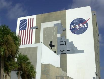
At the Cape, apparently the VAB came thru OK. Unlike Hurricane Jeanne in 2004 which caused some panels to rip away (photo below of the damage in 2004). The big fear was that Matthew was going to hit directly with stronger winds than Jeanne, but it didn't get that close.
I am out personally out surveying Cape Canaveral Air Force Station for damage in order to give everyone some visuals on what I am seeing today. Some of our older building, like the one pictured had significant damage. Please be patient as we get our teams in place for more detailed assessments and debris clean-up. I'll provide an update on Patrick Air Force Base soon.
https://www.facebook.com/45thSpaceWing/photos/pcb.10157366221000012/10157366220475012/?type=3
"Bright spot" about the above pic..... at least the electricity is on....at that location anyway. No idea of what that building is, and he said several had significant damage such as that one.
In an update, the base housing areas were checked out. No major damage to the homes, more like gutters and roof shingles, and trees blown down onto roads. Base is closed, families that had to evacuate will be waiting awhile for the base to reopen. The base Commander is giving frequent updates.
At the Cape, apparently the VAB came thru OK. Unlike Hurricane Jeanne in 2004 which caused some panels to rip away (photo below of the damage in 2004). The big fear was that Matthew was going to hit directly with stronger winds than Jeanne, but it didn't get that close.
Last edited:
- Joined
- Jul 29, 2014
- Messages
- 2,114
- Reaction score
- 715
George, thanks for taking the time to make those reports of the storm damage and the history of other damage from storms.
Similar threads
- Replies
- 2
- Views
- 253
- Replies
- 32
- Views
- 1K