Bluefin Tuba 4"

The Rocketry Forum

Help Support The Rocketry Forum:

This site may earn a commission from merchant affiliate links, including eBay, Amazon, and others.
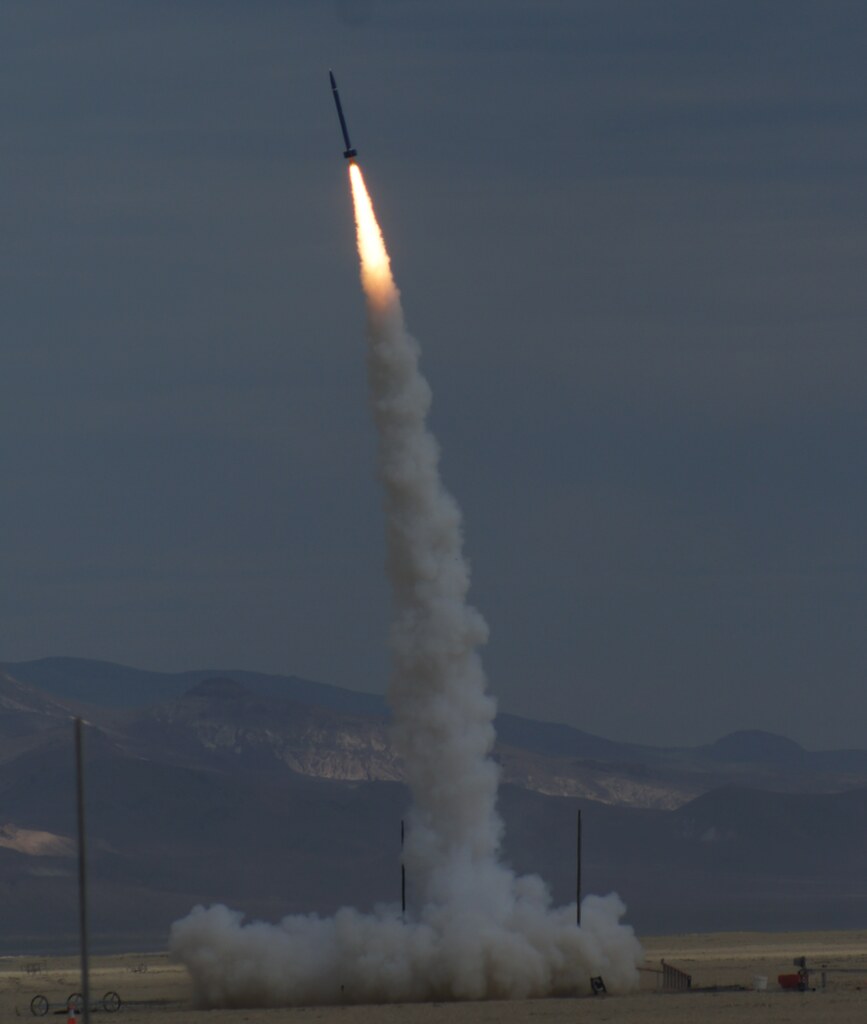
N2000 bought and paid for. Remember the Commitment/Aspiration photo? Now I get to fill that aspiration with AP.

Too bad I can't take physical delivery of the motor until two weeks from now. California law prohibits sale of motors larger than M. I have to wait until the vendor and I are both in Nevada for AeroNaut to handle the motor myself.

Also, confirming N2000 flight at Aeronaut in two weeks.

Ari.
 
This will be really interesting. N2000W isn't much beyond the L1520 in terms of average impulse (obviously), and it's regressive in nature. The first few seconds will be exciting.
 
Finally got data from my StratoLogger.

I invite people who understand this better than me to comment on the speed of this tubefin. I'm attaching also the raw data from altimeter, if case anyone has deeper insights.

Ari.

L1520.png

View attachment L1520.pf2
 
Rocket all prepped for launch next Saturday. Parachutes packed, shear pins in, all ready to go. Weight without motor is 5,250g. According to AT catalog, N2000 weighs 12,412g. Motor is over 2/3 of the pad weight!

Took a photo of all three BFTs together--who knows if the big one is coming back. To my knowledge, this is the first tubefin to fly on on N.

Ari.

IMG_4132.jpg

IMG_4128.jpg
 
Last edited:
I'm eagerly awaiting a flight report!


Here's wishing you guys the best!


Later!

--Coop
 
BFT4 flew to 18,588' this morning and recovered safely. Videos and launch photos forthcoming. For now, two iPhone photos. Recovery photo shows the whole train in one straight line from booster to main, no twisting, no tangling. The rocket is completely intact, except the the vinyl lettering that burned off. A very enjoyable and fulfilling flight!

Ari.

IMG_4135.jpg

IMG_4139.jpg
 
You don't often see tube fins with mach rash. What motor was it on? What was the peak velocity?

Edit: I see the motor listed in the earlier posts. Congrats
 
My friend Walter Colby sends these videos.

Ari.

[video=youtube;zqlerf60jHM]https://www.youtube.com/watch?v=zqlerf60jHM[/video]
[video=youtube;Vp5Kwf14FJk]https://www.youtube.com/watch?v=Vp5Kwf14FJk[/video]
 
Here's a picture I took with Alex's camera, I can send you the full res if you want. Alex is going to upload his video in the morning. Awesome flight man!

 
Hey Ari, Here's the flightline vid I got of your flight. Looked great!

[video=youtube;HMkxLi6po0M]https://www.youtube.com/watch?v=HMkxLi6po0M[/video]

Alex
 
Yes, it was a great flight Ari. Like everyone else it weathercocked into the wind but it was straight as an arrow after that.
 
Thank you for the photos and for the encouragement. It was a happy launch for me!

Here's the data download from StratoLegger, both raw data and a screenshot. Main unfurled right away this time :=)

Eggfinder telemetry worked reliably all the way up and down. The two altimeters almost agree on apogee.

Ari.

N2000.png

View attachment N2000.pf2

IMG_4138.jpg
 
**Standing ovation**

Well done, my friend! Congratulations! Spectacular in every way!


Later!

--Coop
 
BFT4 flew last week at ROC and had a hard landing. All 6 fins came off. Lucky with this type of construction, repair is easy. The fillets, which are the hard part of the build, were still there, just split into halves :=) I was able to glue them all together in one sitting. Looking forward to flying BFT4 again at LUNAR Snow Ranch weekend after next.

Ari.

1458785405005.jpg

1458785414297.jpg

1458785468716.jpg
 
Last edited:
Repairs complete, BFT4 flew again at Snow Ranch yesterday, this time on L850. I'm waiting for in-flight photos. For now, before and after shots.

For this flight, I added an FrSky R/C reciever of the kind I use in my gliders, and a GPS sensor. While the altitude readout (9,221') is bogus, the ground track is in line with reality. An interesting measurement is RSSI (received signal strength indicator, i.e., how well is the radio link holding up). On the graph, I don't have a good liftoff point, but the .7 V dips in battery voltage corresponds well with apogee and main deployments. With this timing in mind, RSSI deteriorates steadily with altitude, but returns to workable levels at apogee. It improves gradually as the rocket descends and eventually drops to 0 as it lands behind a hill. What's interesting is the dropout before apogee. My first reaction is to attribute it to range, but I wonder if it has as much to do with trigonometry as distance. As the rocket ascends, its longitudinal axis aligns with the line between receiver and transmitter antennas. As this happens, motor casing shields more of the signal. As the rocket arcs over and apogee deployment occurs, the rocket presents different sides to the ground station, re-establishing RF link. This description can explain how RSSI returns to normal so soon after apogee, while the rocket is still high above the ground.

For completeness, I also attach StraoLogger output, which reports a much more believable 7,509'.

Ari.

20160402_133633.jpg

20160402_131147.jpg

2016-04-02.snow-ranch.L850.jpg

2016-04-02.snow-ranch.L850.png

2016-04-02.snow-ranch.L850.pf2.png
 
I love the recovery photo. Always neat to see a safely recovered rocket all laid out neat and clean like that. Congratulations on the 'return to flight' after repairs.
 
How you using the FrSky kit. I'm a CAA UAV registered pilot also using the FrSky Taranis. Just wandering if that's what's being used
 
How you using the FrSky kit. I'm a CAA UAV registered pilot also using the FrSky Taranis. Just wandering if that's what's being used

I'm unclear on your question, Pete. While I did some full-size flying in Scotland in the early 2000s, I am ignorant of more recent British UAV regulations and the implications of "CAA UAV registered pilot"

Ari.
 
I'm unclear on your question, Pete. While I did some full-size flying in Scotland in the early 2000s, I am ignorant of more recent British UAV regulations and the implications of "CAA UAV registered pilot"

Ari.

CAA is UK's version of FAA as far as I understand.

I fly commercially for a living so am registered.

Was are it using the Taranis TX to get the data or something other.

Any photos of the setup
 
Pete, I own an original Taranis (before plus). I use an X6R receiver and an FrSky GPS sensor. English is my third language. I hope I'm parsing the syntax of your question correctly.

Speaking of parsing, your signature lists 11 successful flights out of 12, and a success rate of 99%. I should think 99% success rate with 12 flights corresponds to 0.12 failures rather that 1.

Ari.
 

Latest posts

Back
Top