Best Features in a Rocket Tracker/Altimeter

The Rocketry Forum

Help Support The Rocketry Forum:

This site may earn a commission from merchant affiliate links, including eBay, Amazon, and others.

AdamBravo

New Member
Joined
Dec 21, 2014
Messages
2
Reaction score
0
Hey everyone,

I am designing and building my Level 2 rocket as well as a Tracker/Altimeter from scratch. I have some experience designing embedded systems and working with sensors. I am hoping to get other people's input to the design and what features would be good to add.

In general, I want to make a Tracker with several miles of coverage and an Altimeter with multiple deployment charge channels capable of dual deployment and staging. The system will transmit all telemetry and will be able to accept commands from a simple ground station that plugs into a computer over USB. I will be designing the circuits boards and writing the software from scratch.

Detailed features and specs are...
-Definitely small enough to fit in 38mm, maybe within 29mm rocket
-GPS module
-500mW Transmission power in the 900Hz ISM band (Not HAM)
-Pressure sensor accurate to a foot
-Either an IMU (Accelerometer, Gyroscope, Magnetometer) or a high G one axis accelerometer. (Would like an opinion on this)
-On board storage for flight data
-Multiple charge channels, at least two
-Smart Altimeter than can also handle staging
-Radio controlled settings, read out of real time telemetry and location, even control of charge channels
-Powered by LiPo battery with charging circuit on board
-Single Micro USB connector for charging and data transfer to a computer

I look forward to your input on what you think makes a good rocket Tracker/Altimeter (Don't really know what to call it exactly)
 
Why don't you save yourself the trouble and buy yourself an EggFinder TRS and be done with it. If you want all the bells and whistles, the Altus Metrum products are mighty fine and the TeleMega does just about everything you want except it's on the Ham 70cm band. (I purchased their Easy Mega as I have enough trackers already to help support their business.)

Icksnay on the 500mW as the ISM band is limited to 100mW. Major problem with combining tracker Rf with deployment electronics is keeping Rf out of the computer side. The interference problem is very real and I've witnessed deployments on the pad, deployments on ascent and no deployment at all leading to
a very messy ballistic recovery. All this due to Rf dorking the deployment electronics. More Rf power is not necessarily better.

You basically want to do a Tele-Mega on 900Mhz: https://altusmetrum.org/TeleMega/

The EggFinder is here: https://www.eggtimerrocketry.com/Home_page_1.php

In the air, you can easily get a few miles coverage and getting you to the last known packet is close enough to pick up a new position if you can't see the rocket.

I'm impressed with your initiative but you really don't have to go through all that trouble. Would be ashame to have the electronics thwart a perfectly good attempt.
Kurt
 
As Kurt says, the most innovative right now is the AltusMetrum line.

Yup,

Again, I'm impressed with your initiative. (I wasn't being flip in that regard.) There is a fellow who cloned an Altus Metrum product for his own mortification and sold one of them. Had the originator's blessing too. There's a thread here somewhere. Kurt
 
I would be very leery of a pure GPS based tracking system. At our last launch a rocket disappeared after motor burnout. After no one saw the smoke of apogee deployment, or the main deployment, the GPS data packets were checked and the last one transmitted when the rocket was still 8,000 ft. up. There was no clue where the rocket had landed.

As it turned out, the receiver and laptop were rebooted and the packets being broadcasted were picked up again and the rocket location was determined. Then the number entered into the handheld unit said the rocket was 20 miles away. We ended up using a cell phone app to determine the rocket was only 3,200 ft away. This worked because the rocket was 50 ft. up a tree on a hill side slope facing the launch site. If it had landed in a ravine behind a hill, it might have never picked up the data packets.

The GPS system may have been able to be used if it was moved close enough to the rocket to begin picking up packets again if it couldn't get them when at the launch site.

A RDF system may not be as hi-tech, but I think in many cases, simpler is better and a RDF system is certainly simpler. I'm not convinced the more modern but more complicated GPS systems are as rugged and dependable as the proven RDF systems.

Just something to consider.

The problem is one has to be well versed with the GPS tracking system they are using. One has to input the coordinates exactly into a handheld unit. If the received packets are Decimal degrees, you better make danged sure that's what you input and the mapping GPS is set to accept those units. That is the most frequent error one can commit. That is likely the reason for the 20 mile error. Better to practice at home with the manual and not at a launch.

Laptop trouble? Well heck yeah, that can be a big issue if depending on a laptop for position. Again, one needs to practice on their system at home. Learning time is not at the launch. I've been there and done that. Backup, backup and have a backup plan. Looks like you did when they used a cell phone app and finally got it right.

APRS tracking with a purpose built radio into a handheld mapping GPS is as about as bullet-proof as it gets. But....... It costs a heck of a lot. I remember a Ham trying to input the units from his radio into his handheld Garmin GPS at a launch. Got it all wrong. Fortunately,
rocket was found. He was a very happy camper when I showed him the cable he could use that would put the packets into his Garmin 60CsX automagically in realtime and showed him the settings to use with the Garmin.

RDF is the only option for some small projects and yes it can work well. I've seen projects go missing with RDF trackers when they got out too far and a good primary fix wasn't had. Also, no matter what system you use you need to do a full range check with the in-situ tracker bay. Use metallic paint or have the antenna parallel to some metal all-thread and close range you're fine, 8000' up you're not. (Been there and done that too. Metallic paint)

So, I would be very leery of any tracking system where the user wasn't well-versed or well-practiced with it period. Kurt
 
Yup,

Again, I'm impressed with your initiative. (I wasn't being flip in that regard.) There is a fellow who cloned an Altus Metrum product for his own mortification and sold one of them. Had the originator's blessing too. There's a thread here somewhere. Kurt

I'm probably that guy. Yes, you have to be a glutton for punishment. Unfortunately, I'm getting ready to make another couple. My spare bit the dust on a ride-along flight that was motor eject. Long story short, the motor didn't eject and the rapid negative acceleration when it buried itself in the Kansas soil stripped parts off of the board.

Bdale and Keith are great guys and were pretty impressed with the boards I made. At the very least, you could start with their designs and work from there. Feel free to drop a PM if you have any questions.

Doug
 
I double checked the FCC Part 15 rules for ISM 900 MHz and its a maximum throughput of 30 dBm or 1 Watt. The Xbee S3B 900 MHz radios do 250 mW so I think I should be okay unless there is another rule I'm not aware of. The reason I want to build one from scratch is I don't want to pay a lot of money for a HAM tracker and radio. I don't know too much about RDF other than a very directional antenna is needed on the receiver side. Does there need to be anything special about the antenna? Thank you all for your responses.
 
I double checked the FCC Part 15 rules for ISM 900 MHz and its a maximum throughput of 30 dBm or 1 Watt. The Xbee S3B 900 MHz radios do 250 mW so I think I should be okay unless there is another rule I'm not aware of. The reason I want to build one from scratch is I don't want to pay a lot of money for a HAM tracker and radio. I don't know too much about RDF other than a very directional antenna is needed on the receiver side. Does there need to be anything special about the antenna? Thank you all for your responses.

I would think it's going to cost you for the board(s), take time to build and test the system and get it to work. How much is your time worth? I stand corrected on the power output: https://www.afar.net/tutorials/fcc-rules. One watt into a 6dbi gain antenna it is.

You don't need to get a ham tracker for GPS tracking. Do the Egg Finder or the TRS. Or I can post the Rocksim file for my 4" 3FNC with LOC tubes and stuff a
38mm J350M in it and pull off the cert with motor ejection. You then will have access to up to an L and you can play with the electronics all you want. Or you can get experience with H and I DD's to save on the propellant costs and go from there.

The 70cm band has some range advantages but if you are a sport flyer and not a record hunter, you should be fine.
 
Detailed features and specs are...
-Definitely small enough to fit in 38mm, maybe within 29mm rocket
-GPS module
-500mW Transmission power in the 900Hz ISM band (Not HAM)
-Pressure sensor accurate to a foot
-Either an IMU (Accelerometer, Gyroscope, Magnetometer) or a high G one axis accelerometer. (Would like an opinion on this)
-On board storage for flight data
-Multiple charge channels, at least two
-Smart Altimeter than can also handle staging
-Radio controlled settings, read out of real time telemetry and location, even control of charge channels
-Powered by LiPo battery with charging circuit on board
-Single Micro USB connector for charging and data transfer to a computer

I look forward to your input on what you think makes a good rocket Tracker/Altimeter (Don't really know what to call it exactly)

We call it TeleMetrum, except that we use the 70cm amateur band because we can get better range with that, and don't need to get our products FCC certified :)

In terms of IMU vs one-axis accelerometer, note that the only IMUs we've found have a maximum acceleration of about 15gs, which isn't really enough to cover common rocket flights. So, if you want to measure acceleration or speed during flight, you'll need a high-g linear accelerometer.

I can highly recommend the adventure of building your own electronics; we're still having a great time building electronics and flying rockets. Knowing that it's your hardware and software getting the rocket back to you safely is quite satisfying. I don't know how much experience you have building custom hardware and writing embedded firmware; if you're well practiced, it should be well within reach; it's only rocket science, and not brain surgery, after all. If you're just begining, I'd encourage you to start with a subset of your planned feature set and work up from there.

I'd encourage you to steal from existing designs to shorten the learning curve. All of our hardware designs and software are freely licensed; you can do whatever you like with it (even sell products). The only requirement is that you share what you've done.
 
I'd encourage you to steal from existing designs to shorten the learning curve. All of our hardware designs and software are freely licensed; you can do whatever you like with it (even sell products). The only requirement is that you share what you've done.

THIS is so dang cool it's............it's........................ummm......................it's......just so DANG cool.

s6
 
The problem is one has to be well versed with the GPS tracking system they are using. One has to input the coordinates exactly into a handheld unit. If the received packets are Decimal degrees, you better make danged sure that's what you input and the mapping GPS is set to accept those units. That is the most frequent error one can commit. That is likely the reason for the 20 mile error. Better to practice at home with the manual and not at a launch.

Laptop trouble? Well heck yeah, that can be a big issue if depending on a laptop for position. Again, one needs to practice on their system at home. Learning time is not at the launch. I've been there and done that. Backup, backup and have a backup plan. Looks like you did when they used a cell phone app and finally got it right.

APRS tracking with a purpose built radio into a handheld mapping GPS is as about as bullet-proof as it gets. But....... It costs a heck of a lot. I remember a Ham trying to input the units from his radio into his handheld Garmin GPS at a launch. Got it all wrong. Fortunately,
rocket was found. He was a very happy camper when I showed him the cable he could use that would put the packets into his Garmin 60CsX automagically in realtime and showed him the settings to use with the Garmin.

RDF is the only option for some small projects and yes it can work well. I've seen projects go missing with RDF trackers when they got out too far and a good primary fix wasn't had. Also, no matter what system you use you need to do a full range check with the in-situ tracker bay. Use metallic paint or have the antenna parallel to some metal all-thread and close range you're fine, 8000' up you're not. (Been there and done that too. Metallic paint)

So, I would be very leery of any tracking system where the user wasn't well-versed or well-practiced with it period. Kurt

I understand how the gps systems work and I've used our Walston RDF a lot so I'm very familiar with that. I guess I just tend to go with "If it ain't broke, don't fix it" idea. I know that's part old age, but I know what the limitations of the RDF systems are. I have only watched a few people use the GPS systems and there seems to be more things that can go wrong with them. At the last launch, rebooting the laptop got the system working again and it began receiving packets again. If they hadn't gotten any more packets, then what? With a RDF I'm sure I would have began getting a signal again as I move down range and got closer to the transmitter even if it is in a ditch. Is that always true with GPS? I assume it is, but if the transmitter is in a location that isn't transmitting packets well, is the GPS receiver still getting satellite fixes well enough to know where it is at? Or does a poor transmitting location also mean it can't get good satellite fixes too? Will it still transmit it's last good position, or does it start transmitting bad location data?
 
The GPS satellite data reception and the transmission of that data to your receiver are two independent events, so if you lose the link to your GPS/altimeter that doesn't mean that the GPS fix isn't good. It just means that you aren't receiving the GPS data, as soon as you get a link you'll get the fix. Normally, the last received fix before landing is very close to your actual landing spot. The distance at which you can maintain the link depends on the radio; an Eggfinder is good for 10,000'-20,000' depending on the antennas, a 70 cm unit like the Telemetrum will get you somewhat more distance but you'll need a Ham license to use it.
 
The GPS satellite data reception and the transmission of that data to your receiver are two independent events, so if you lose the link to your GPS/altimeter that doesn't mean that the GPS fix isn't good. It just means that you aren't receiving the GPS data, as soon as you get a link you'll get the fix. Normally, the last received fix before landing is very close to your actual landing spot. The distance at which you can maintain the link depends on the radio; an Eggfinder is good for 10,000'-20,000' depending on the antennas, a 70 cm unit like the Telemetrum will get you somewhat more distance but you'll need a Ham license to use it.

About the Ham 70cm systems. One can usually has the option to "send only valid" data packets which means the device may only transmit when there is a GPS lock. Oherwise it's silent.
There is the option to have a device to transmit "no matter what". Why do that? Well, if one is really in a bind, they can still use an RDF setup to home in on a downed rocket. The transmitter only has to put out Rf. In reality for sport fliers, the last received packet is usually pretty darned close to the rocket like Cerving mentions above.

I can open the squelch on my radio and hear the transmitter from while still a long distance away with the receiver unable to decode the position. At that point, I know the tracker is still "alive" and stand a chance to get a new packet while getting closer. Since I haven't had to recover anything farther than 2 miles, the icon
usually doesn't jump much. That said, the new EggFinder and TRS are pretty darned good and folks don't have to be hindered by not being a Ham. It's more than
adequate for a sport flier. Rocket goes down in tall grass or standing corn within a couple of miles? Piece o' cake getting it back! Kurt
 
The GPS satellite data reception and the transmission of that data to your receiver are two independent events, so if you lose the link to your GPS/altimeter that doesn't mean that the GPS fix isn't good. It just means that you aren't receiving the GPS data, as soon as you get a link you'll get the fix. Normally, the last received fix before landing is very close to your actual landing spot. The distance at which you can maintain the link depends on the radio; an Eggfinder is good for 10,000'-20,000' depending on the antennas, a 70 cm unit like the Telemetrum will get you somewhat more distance but you'll need a Ham license to use it.

In the case at our launch, I'm sure the satellite data reception was good the whole time. The problem was the transmission to the receiver stopped while the rocket was still at 8,000 ft. The rocket ended up hung in a tree so when the receiver was power cycled and started picking up transmissions from the rocket again, it was getting good strong signals. My worry would be in a case like this, if the rocket landed in a raven or some place where the transmitted signal wouldn't propagate very well, how would you get a good location for the rocket if you never got that "last good data packet". The RDF system is easy to use in the field and highly portable, but the GPS antenna, receiver and laptop, not so much. It just seems it would be much harder to get a fix on the rocket if you didn't get that "last good data packet" and had to lug the whole system around to find the transmitter again.
 
The RDF system is easy to use in the field and highly portable, but the GPS antenna, receiver and laptop, not so much. It just seems it would be much harder to get a fix on the rocket if you didn't get that "last good data packet" and had to lug the whole system around to find the transmitter again.
Not all GPS systems require a laptop. Some units come with dedicated hand-held receivers and others can be used with a phone/tablet instead of a full computer.

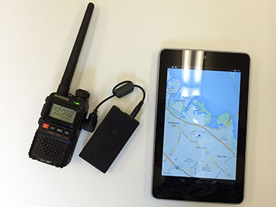
baofeng-tnc-droid.jpg


As a long-time user of Walston systems (animal tracker frequencies), going back to RDF from GPS is a definite step backwards for recovery, not to mention the advantages of telemetry.

Radio links work best before landing, and if your GPS TX can't reach your location, RDF will be iffy as well. With GPS, you will have a series of positions as the rocket descends, so even if you can't receive packets on the ground the last position you got in the air will be close to the landing spot.
 
It just seems it would be much harder to get a fix on the rocket if you didn't get that "last good data packet" and had to lug the whole system around to find the transmitter again.

With the Altus Metrum stuff, you've got choices. You can use a laptop, Android device, APRS receiver or a regular RDF'ing HT for a ground station.

With an Android phone or tablet, you connect over BlueTooth to the 70cm receiver which mounts right on the antenna. It takes two hands to point the antenna and look at the screen, but most of the recovery can be done using whatever data you've already received.

We record the last GPS position computed and re-transmit that, in case the GPS receiver loses lock after landing. Plus, you'll get an RDF beacon in case the GPS position isn't useful.
 
In the case at our launch, I'm sure the satellite data reception was good the whole time. The problem was the transmission to the receiver stopped while the rocket was still at 8,000 ft. The rocket ended up hung in a tree so when the receiver was power cycled and started picking up transmissions from the rocket again, it was getting good strong signals. My worry would be in a case like this, if the rocket landed in a raven or some place where the transmitted signal wouldn't propagate very well, how would you get a good location for the rocket if you never got that "last good data packet". The RDF system is easy to use in the field and highly portable, but the GPS antenna, receiver and laptop, not so much. It just seems it would be much harder to get a fix on the rocket if you didn't get that "last good data packet" and had to lug the whole system around to find the transmitter again.

John is too modest.:eek: Go to his website and read about GPS tracking if you haven't done so already: https://www.jcrocket.com/gps-tracking.shtml Kurt
 
The problem is one has to be well versed with the GPS tracking system they are using. One has to input the coordinates exactly into a handheld unit. If the received packets are Decimal degrees, you better make danged sure that's what you input and the mapping GPS is set to accept those units. That is the most frequent error one can commit. That is likely the reason for the 20 mile error. Better to practice at home with the manual and not at a launch.

Laptop trouble? Well heck yeah, that can be a big issue if depending on a laptop for position. Again, one needs to practice on their system at home. Learning time is not at the launch. I've been there and done that. Backup, backup and have a backup plan. Looks like you did when they used a cell phone app and finally got it right.

Absolutely correct. I practiced with my BRB900 at home for months before putting it in a rocket. I let my kids hide the transmitter while I tried to find it. I also did some nerdy geocaching to practice with the Garmin and learn GPS, waypoints, tracks, etc.

Once, during a launch, when I punched in the BRB900 coordinates to the Garmin, it said my rocket was 6000 miles away! I initially freaked out, then systematically worked through my procedure. User error. I put in East longitude instead of West longitude, so it thought my rocket was in China somewhere! My previous practice helped me resolve the problem quickly.

Yes, backup. I carry a Garmin handheld and two GPS apps on my smartphone, and I know how to use all of them. The laptop receiver is nice for streaming data and stuff, but I don't want to be tied down. I prefer the handheld BRB900 receiver to stay mobile. My last recovery was Mach 1.4, 12k ft, and landed 2.25 miles away. The BRB900 GPS worked flawlessly.

I never used RDF, so I can't comment on that. I jumped right into GPS because it is modern and intuitive to me.
 
Back
Top